Appendix - Peak District National Park Authority
Appendix - Peak District National Park Authority
Appendix - Peak District National Park Authority

You also want an ePaper? Increase the reach of your titles
YUMPU automatically turns print PDFs into web optimized ePapers that Google loves.
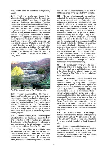
1760 until th e mid-nin eteenth ce ntury (Buxton,2005).3.19 The first tu rnpike road throug h thevillage, the Sparrowpit to Sheffield Turnpike, wasconstructed i n 17 58. T his followed th e old Daletrack from Ringinglow ov er Burbage Brook toHathersage, continuing along the Hope Valley toCastleton a nd west ward via Sparrowpit toStockport. T he turnpi ke originally foll owed theoriginal tra ck past Callow Field s Fa rm towa rdsFiddlers’ Elbow, but this route was very exposed,and the steep stretch was found t o be toodangerous for wagons and carriages. As a result,the turnpike was re-routed in 1767 to avoid thisstretch, and instead foll owed a more grad ualloop past Overstones (McGuire et al, 2 000). Theoriginal, dire ct ro ute and the ne wer, diverte droute are b oth cl early visi ble o n Bu rdett’s 179 1Map, running to either side of the Cupola north ofMitchell Fi eld (Fig ure 5 ). The remai ns of th eabandoned stretch of roa d ca n still b e see n onthe ground.P3.4 The original route of the 1758 Turnpike3.20 The con struction of the Sheffield toSparrowpit Turnpike road led to the expansion ofthe settleme nt west wards alon g the valleybottom. The resulting line ar layout of building salong the p resent-day Main Road can be clearlyseen on Burdett’s Map of 1791. The turnpi ke i slikely to have led to an increase in the number ofinns in th e village, and t he Geo rge Hotel an dScotsman’s Pack appear to have late-eighteenthcentury origins.3.21 A further turnpike, from Hathersage toChesterfield via Fox Hou se, was started in 1 781and complet ed in 182 5. The turn pike betwee nGrindleford a nd Bamford, throug h Hathersag e,was const ructed in the lat e eightee nth centu ry,but is not yet visible on Burdett’s 1791 Map.3.22 The o riginal Ringi nglow to Hathe rsagesection of the 1758 turn pike road ha d lost itsturnpike stat us by 1811, when a ne w turnpi kefrom Whim Corne r to Burba ge Brook wasconstructed (Buxton, 2005). Th e Ordna nceArms, renamed the Hath ersage Inn in 1960 andnow a n outd oor e quipment sho p, wa s built in1808 in advance of the expected 1811 turnpike.3.23 The turn pikes improved transport intoand out of the settlement, not only of people butalso of raw materials and manufactured goods toand from the small -scale mill-sites o n Mill Lan eand i n Th e Dal e. Mo st impo rtantly, the n ewturnpike along Hope Vall ey facilitated access tothe wate r-power p otential of the Hood Brook inthe valley bottom. As a res ult, there was adramatic in crease in th e gro wth o f waterpoweredind ustry from the begin ning of thenineteenth century New mills were constructedon the ea st side of the Hood B rook, a ccessiblefrom the turnpike road, and an expansion of theDale Broo k mill site. By 1820 the re were fou rwater-powered mills at the ends of thesettlement, three beside the Hood Brook and onein The Dale. The mills converted to steam-powerfrom the 1840s and a f ifth mill, Darvill’s Mill,occupied part of Mill Ban k Court on Main Road.The Hathersage mill s specialised p rimarily i nwire-drawing; this p articular in dustry is likely tohave co ntinued in th e village sin ce itsintroduction in the sixteenth century.3.24 The co nstruction of the turnpi ke road s,and the exp ansion of in dustry al ong the Hoo dBrook to the west, led to a shift in the main focusof the village from the original hi storic co re atBank Top and in T he Dale, to the vall ey bottomalong Main Road.3.25 The expa nsion of the mil ls would h averesulted i n a corresponding in crease i npopulation, includi ng many trade s-people,together with a gradu al shift from agriculturalwork a s mo re job s were availabl e in indu stry.Purpose-built terraces of prope rties wereconstructed to house th e mill workers. Thesewere small-scale, relatively simple an d of a typemore typically found in u rban settlements, wherespace would have been at a p remium, than in arural village. Back-to-back cottages were built onStation Roa d but had be en dem olished befo re1914. Two of the earlie st remai ning terra ces,Downing Co ttages an d Oddfello ws Ro w, areboth visibl e o n the 18 80 Ordnance Su rvey Map(Figure 6).3.26 The number of inns i n the villageincreased from this time, to cater for the growingnumber of mill workers. An earlier inn on the siteof the Little John Hotel, known a s the Butcher’sArms, was located close to the Hood Brook millsites.3.27 Steam power enabled the mills toexpand further and increase production. Wealthymill owners and landowners started to build largehouses for themselve s, in or just outsideHathersage, inclu ding Ro ck Ho use and NetherHall (outside the Conservation Area).9