Appendix - Peak District National Park Authority
Appendix - Peak District National Park Authority
Appendix - Peak District National Park Authority

Create successful ePaper yourself
Turn your PDF publications into a flip-book with our unique Google optimized e-Paper software.
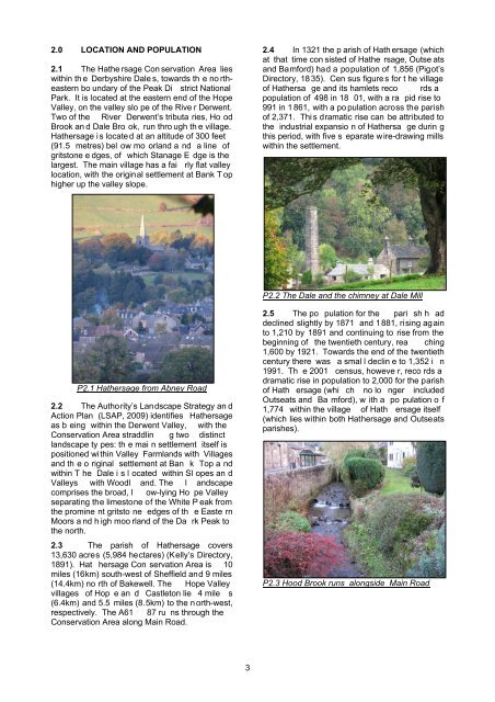
2.0 LOCATION AND POPULATION2.1 The Hathe rsage Con servation Area lieswithin th e Derbyshire Dale s, towards th e no rtheasternbo undary of the <strong>Peak</strong> Di strict <strong>National</strong><strong>Park</strong>. It is located at the eastern end of the HopeValley, on the valley slo pe of the Rive r Derwent.Two of the River Derwent’s tributa ries, Ho odBrook an d Dale Bro ok, run thro ugh th e village.Hathersage i s locate d at an altitude of 300 feet(91.5 metres) bel ow mo orland a nd a line ofgritstone e dges, of which Stanage E dge is thelargest. The main village has a fai rly flat valleylocation, with the original settlement at Bank T ophigher up the valley slope.2.4 In 1321 the p arish of Hath ersage (whichat that time con sisted of Hathe rsage, Outse atsand Bamford) had a population of 1,856 (Pigot’sDirectory, 18 35). Cen sus figure s for t he villageof Hathersa ge and its hamlets reco rds apopulation of 498 in 18 01, with a ra pid rise to991 in 1 861, with a po pulation across the parishof 2,371. Thi s dramatic rise can be attributed tothe industrial expansio n of Hathersa ge durin gthis period, with five s eparate wire-drawing millswithin the settlement.P2.2 The Dale and the chimney at Dale MillP2.1 Hathersage from Abney Road2.2 The <strong>Authority</strong>’s Landscape Strategy an dAction Plan (LSAP, 2009) identifies Hathersageas b eing within the Derwent Valley, with theConservation Area straddlin g two distinctlandscape ty pes: th e mai n settlement itself ispositioned within Valley Farmlands with Villagesand th e o riginal settlement at Ban k Top a ndwithin T he Dale i s l ocated within Sl opes an dValleys with Woodl and. The l andscapecomprises the broad, l ow-lying Ho pe Valleyseparating the limestone of the White P eak fromthe promine nt gritsto ne edges of th e Easte rnMoors a nd h igh moo rland of the Da rk <strong>Peak</strong> tothe north.2.3 The parish of Hathersage covers13,630 acres (5,984 hectares) (Kelly’s Directory,1891). Hat hersage Con servation Area is 10miles (16km) south-west of Sheffield and 9 miles(14.4km) no rth of Bakewell. The Hope Valleyvillages of Hop e an d Castleton lie 4 mile s(6.4km) and 5.5 miles (8.5km) to the n orth-west,respectively. The A61 87 ru ns through theConservation Area along Main Road.2.5 The po pulation for the pari sh h addeclined slightly by 1871 and 1881, rising againto 1,210 by 1891 and continuing to rise from thebeginning of the twentieth century, rea ching1,600 by 1921. Towards the end of the twentiethcentury there was a smal l declin e to 1,352 i n1991. Th e 2001 census, howeve r, reco rds adramatic rise in population to 2,000 for the parishof Hath ersage (whi ch no lo nger includedOutseats and Ba mford), w ith a po pulation o f1,774 within the village of Hath ersage itself(which lies within both Hathersage and Outseatsparishes).P2.3 Hood Brook runs alongside Main Road3