Appendix - Peak District National Park Authority
Appendix - Peak District National Park Authority
Appendix - Peak District National Park Authority

Create successful ePaper yourself
Turn your PDF publications into a flip-book with our unique Google optimized e-Paper software.
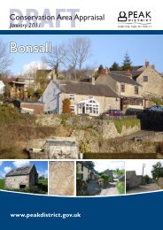
11.0 POTENTIAL FOR IMPROVEMENT11.1 The intention in this Section is to examinethe spe cial character a nd appe arance of theConservation Area and identify opport unities forimprovements.11.2 In 1981 a Con servation AreaManagement Plan was d rawn up for Hathersageby the then <strong>Peak</strong> Pa rk Joint Planning Board andthe Parish Council, in collaboration with the localcommunity. This led to a number ofimprovements being ca rried out, including: treeplanting in vario us site s and refu rbishing theMemorial street lamp in the early 1980s; repavingin front of Bank Cottages at Besom L ane a ndimproving th e forme r p etrol statio n site atDowning Row in 1984; improvements to footpathsat Barnfield and bet ween the chu rch and Baul kLane in 1 986; landsca ping the roa dside vergenear Hath ersage Hall in 1988; a nd p roviding anew footpath link between the car park and MainRoad in 1990.11.3 In 2005 the Hathersag e and Outsea tsVillage Plan was drawn up by the Hathersage andOutseats Vi llage Plan Steering Group, inconjunction with the Pea k Di strict <strong>National</strong> <strong>Park</strong><strong>Authority</strong> and Derbyshi re Rural CommunityCouncil, u nder the Countryside Agen cy’s ‘VitalVillages’ Initiative. A number of furtherenvironmental improvements and social/businessobjectives were ide ntified, sh owing furthe rchange to the community’s priorities and aimed atdeveloping a nd en hancing the village’ s spe cialcharacter. A key aim is to improve public highwayspaces alo ng Main Roa d and conn ecting roa dsthrough the village, for rea sons of both amenityand safety, by reducing the impact of car parkin gon impo rtant village spa ces and by redu cingtraffic speeds. The Plan also ide ntified a numberof key enh ancements for the st reet scen e,including reduced road signage, permanent floraldisplays, Chri stmas trees and l ights o ncommercial and publi c buildin gs. The mainproposal is t o enh ance t he pu blic space at theParish Room s to provide a focal-point for thevillage centre . The Village Centre G roup is indiscussion with the <strong>Authority</strong>, Derbyshire Dal es<strong>District</strong> Co uncil, Derbyshi re County Co uncil an dHathersage Pa rish C ouncil w ith a vie w toproducing a n enh ancement and im provementplan for the new village centre.11.4 A review of the Village Plan in September2007 identified the n eed for additional long- andshort-term car parks.11.5 Successful projects ha ve relied o npartnerships between the commu nity, theHathersage and O utseats Village Plan Steeringgroup through 6 specialised sub groups, the <strong>Peak</strong><strong>District</strong> Nati onal <strong>Park</strong> <strong>Authority</strong>, DerbyshireCounty Co uncil, D erbyshire Dale s Di strictCouncil, Harthersage a nd Out seats Pari shCouncils and the Police <strong>Authority</strong>.11.6 The Co nservation A rea is i ncomparatively good condition. The re are f ewneutral or ne gative area s or eleme nts requiringenhancement at the easte rn en d of theConservation Area, from the historic core on BankTop and within The Dale, to the Parish Room andthe Methodi st Church e ntrance o n Ma in Roa d.There are so me improve ments whi ch could bemade, however, if the op portunity was to arise; itshould be noted that the c haracter of this pa rt ofthe Hath ersage Con servation Are a cou ld ea silybe spoiled if it were to become over-manicured.11.7 Twentieth century developments and infillalong M ain Roa d, have red uced mu ch of thesettlement’s original historic form a ndappearance, and the extensive twentiet h centurydevelopments out side th e Co nservation Are aboundary have had a si gnificant impact on itssetting, un dermining th e histo ric boundarybetween the settlement and its surroun dinglandscape. In order to retain what remains of theConservation Area’s hi storic me rit and integrity,special care should be ta ken to en sure that anyfurther chan ges o r deve lopments prese rve orenhance the speci al histori cal and archite cturalcharacter and interest of the Con servation Area,as defined in detail within t his Conservation AreaAppraisal, in order to prevent any further erosionof the area’s special historic interest.11.8 A number of key are as for improveme nthave al ready been ide ntified withi n th e VillagePlan (2005), as outlined in 11.3 a bove. Some ofthe issues mentioned above and below could beaddressed b y the <strong>Peak</strong> Dist rict Natio nal <strong>Park</strong><strong>Authority</strong> and/or De rbyshire Co unty Coun cil.Other item s would n eed to be addressed byprivate indi viduals an d in some case senhancement may not be achievable.Improving modern development11.9 The petrol st ation building and fore courton Main Road could be seen to have a neutral ornegative imp act on the histo ric ch aracter andappearance of the Co nservation A rea at thispoint. Any opportunities to enhance and improvethese elements would have a positive i mpact onthe Conservation Area.11.10 Most of the more re cent mod erndevelopments within the Conservat ion Areaboundary a re co nstructed usi ng sympatheticmaterials.11.11 The Ga rage on Main Road is not inkeeping with the local verna cular in terms ofarchitectural style and use of materials, and has aneutral to negative impact on the visualappearance of the Conservation Area.11.12 Any new d evelopment need s to b edesigned wit h ca re to e nsure that it doe s not47