

Understanding Map Projections
Understanding Map Projections
Understanding Map Projections
- No tags were found...

You also want an ePaper? Increase the reach of your titles
YUMPU automatically turns print PDFs into web optimized ePapers that Google loves.
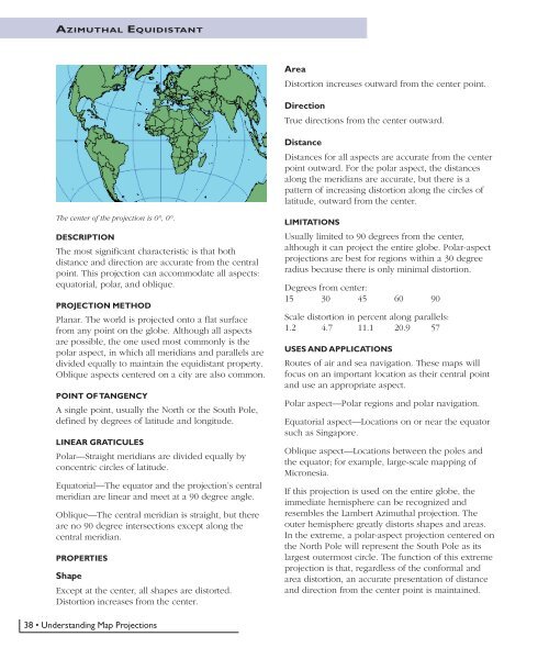
AZIMUTHAL EQUIDISTANTAreaDistortion increases outward from the center point.DirectionTrue directions from the center outward.DistanceDistances for all aspects are accurate from the centerpoint outward. For the polar aspect, the distancesalong the meridians are accurate, but there is apattern of increasing distortion along the circles oflatitude, outward from the center.The center of the projection is 0°, 0°.DESCRIPTIONThe most significant characteristic is that bothdistance and direction are accurate from the centralpoint. This projection can accommodate all aspects:equatorial, polar, and oblique.PROJECTION METHODPlanar. The world is projected onto a flat surfacefrom any point on the globe. Although all aspectsare possible, the one used most commonly is thepolar aspect, in which all meridians and parallels aredivided equally to maintain the equidistant property.Oblique aspects centered on a city are also common.POINT OF TANGENCYA single point, usually the North or the South Pole,defined by degrees of latitude and longitude.LINEAR GRATICULESPolar—Straight meridians are divided equally byconcentric circles of latitude.Equatorial—The equator and the projection’s centralmeridian are linear and meet at a 90 degree angle.Oblique—The central meridian is straight, but thereare no 90 degree intersections except along thecentral meridian.PROPERTIESShapeExcept at the center, all shapes are distorted.Distortion increases from the center.LIMITATIONSUsually limited to 90 degrees from the center,although it can project the entire globe. Polar-aspectprojections are best for regions within a 30 degreeradius because there is only minimal distortion.Degrees from center:15 30 45 60 90Scale distortion in percent along parallels:1.2 4.7 11.1 20.9 57USES AND APPLICATIONSRoutes of air and sea navigation. These maps willfocus on an important location as their central pointand use an appropriate aspect.Polar aspect—Polar regions and polar navigation.Equatorial aspect—Locations on or near the equatorsuch as Singapore.Oblique aspect—Locations between the poles andthe equator; for example, large-scale mapping ofMicronesia.If this projection is used on the entire globe, theimmediate hemisphere can be recognized andresembles the Lambert Azimuthal projection. Theouter hemisphere greatly distorts shapes and areas.In the extreme, a polar-aspect projection centered onthe North Pole will represent the South Pole as itslargest outermost circle. The function of this extremeprojection is that, regardless of the conformal andarea distortion, an accurate presentation of distanceand direction from the center point is maintained.38 • <strong>Understanding</strong> <strong>Map</strong> <strong>Projections</strong>


