

Understanding Map Projections
Understanding Map Projections
Understanding Map Projections
- No tags were found...

Create successful ePaper yourself
Turn your PDF publications into a flip-book with our unique Google optimized e-Paper software.
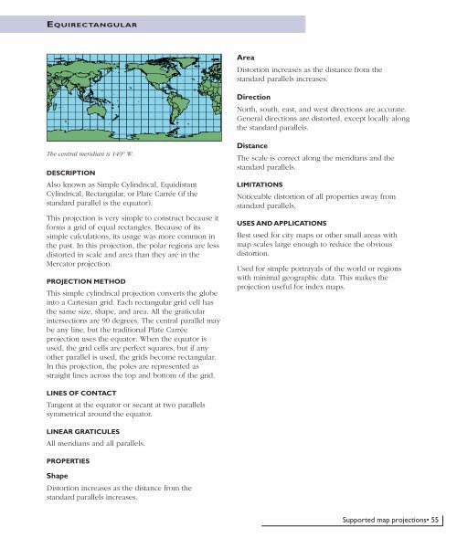
EQUIRECTANGULARAreaDistortion increases as the distance from thestandard parallels increases.DirectionNorth, south, east, and west directions are accurate.General directions are distorted, except locally alongthe standard parallels.The central meridian is 149° W.DESCRIPTIONAlso known as Simple Cylindrical, EquidistantCylindrical, Rectangular, or Plate Carrée (if thestandard parallel is the equator).This projection is very simple to construct because itforms a grid of equal rectangles. Because of itssimple calculations, its usage was more common inthe past. In this projection, the polar regions are lessdistorted in scale and area than they are in theMercator projection.PROJECTION METHODThis simple cylindrical projection converts the globeinto a Cartesian grid. Each rectangular grid cell hasthe same size, shape, and area. All the graticularintersections are 90 degrees. The central parallel maybe any line, but the traditional Plate Carréeprojection uses the equator. When the equator isused, the grid cells are perfect squares, but if anyother parallel is used, the grids become rectangular.In this projection, the poles are represented asstraight lines across the top and bottom of the grid.DistanceThe scale is correct along the meridians and thestandard parallels.LIMITATIONSNoticeable distortion of all properties away fromstandard parallels.USES AND APPLICATIONSBest used for city maps or other small areas withmap scales large enough to reduce the obviousdistortion.Used for simple portrayals of the world or regionswith minimal geographic data. This makes theprojection useful for index maps.LINES OF CONTACTTangent at the equator or secant at two parallelssymmetrical around the equator.LINEAR GRATICULESAll meridians and all parallels.PROPERTIESShapeDistortion increases as the distance from thestandard parallels increases.Supported map projections• 55


