

Uranium ore-forming systems of the - Geoscience Australia
Uranium ore-forming systems of the - Geoscience Australia
Uranium ore-forming systems of the - Geoscience Australia

You also want an ePaper? Increase the reach of your titles
YUMPU automatically turns print PDFs into web optimized ePapers that Google loves.
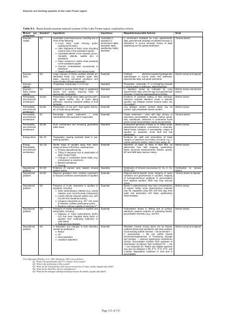
<strong>Uranium</strong> <strong>ore</strong>-<strong>forming</strong> <strong>systems</strong> <strong>of</strong> <strong>the</strong> Lake Frome regionTable 8.1: Basin-hosted uranium mineral <strong>systems</strong> <strong>of</strong> <strong>the</strong> Lake Frome region: exploration criteriaMineral syscomponentSources -metalsSources -fluidsSources -ligandsSources –fluids, metals,ligandsPermeabilityand chemicalarchitecturePermeabilityand chemicalarchitecturePermeabilityand chemicalarchitecturePermeabilityand chemicalarchitectureQuestion # Ingredients Importance Mappable/measurable features ScaleQ3Q3Q3Q3,Q4Q3,Q4Leachable U-enriched source, including one orm<strong>ore</strong> <strong>of</strong> <strong>the</strong> following: U-rich felsic rocks rimming and/orunderlying <strong>the</strong> basin. Lithic fragments <strong>of</strong> felsic rocks (includingvolcanic ash) in <strong>the</strong> sandstone aquifer. Leachable detrital U-rich minerals (zircon,monazite, allanite, apatite etc) insandstone Felsic volcanics in and/or close proximityto <strong>the</strong> sandstone aquifer <strong>Uranium</strong> mineralisation occurrences inhinterland Deeply wea<strong>the</strong>red U-rich source rocksLarge volumes <strong>of</strong> highly oxidised (initially airsaturated)fluids, e.g. meteoric water, lakewater, requiring sub-aerial conditions andmoist climate (at least seasonally)Leachable U:essential; Uenrichment: highlydesirable; deepwea<strong>the</strong>ring: highlydesirableU enrichment indicated by γ-ray spectrometricdata, geochemical analyses <strong>of</strong> potential sources; Udistribution in source minerals; history <strong>of</strong> deepwea<strong>the</strong>ring and its spatial distributionEssential Oxidised alteration/wea<strong>the</strong>ring/diageneticassemblages in source areas and pathways;paleoclimate data; sub-aerial sedimentsPhosphate, bicarbonate, F or Cl ions Desirable Phosphate-, carbonate-, F- or Cl-bearing mineralsin source areas or pathways, altered/leachedLeached U sources (from fresh or wea<strong>the</strong>red Desirable U depletion zones as indicated by γ-raysource rock areas), requiring fluids <strong>of</strong>spectrometric data, wire-line logs and geochemicalappropriate compositionanalyses; U-leached paleowea<strong>the</strong>ring pr<strong>of</strong>ilesPreservation <strong>of</strong> high redox state (and low pH?,high ligand activity, etc) <strong>of</strong> fluids alongpathways, requiring subaerial setting <strong>of</strong> fluidrechargePreservation <strong>of</strong> low pH?, high ligand activity,etc <strong>of</strong> fluids along pathwaysQ1 Permeable clastic sediments / rocksinterstratified with aquitards or aquicludesQ2,Q4Fluid confinement and focussing geometrieswithin basinEnergy driver Q4, Q1 Topography causing hydraulic head in preexistingaquifersEnergy,Permeabilityand chemicalarchitectureDepositionalgradientDepositionalgradientDepositionalgradientDepositionalgradientDepositionalgradientQ4, Q2 Gentle slope <strong>of</strong> aquifers away from basinmargin at times <strong>of</strong> fluid flow, resulting from: Primary depositional dip Tilting <strong>of</strong> sequence due to reactivation <strong>of</strong>basin margin faults Change in continental stress fields (e.g.compression or extension) Basinal subsidence DomingQ1-Q5 Evidence <strong>of</strong> uranium (and related) mineralsystem activityQ4,Q5 Regional gradation from oxidized (upstream)to reduced conditions (downstream) in aquifersQ5Q5Q5EssentialEssentialEssentialDesirableEssentialEvidence <strong>of</strong> subaerial setting <strong>of</strong> fluid recharge;extensive oxidised alteration zones in reducedaquifers; low feldspar content (mature seds); lowCa content?Low feldspar content (mature seds); low Cacontent; high phosphate mineral contentClastic sediments / rocks with high primary orsecondary permeabilities, typically mature sands,silts, sandstones, siltstones in continental fluvialand/or mixed fluvial-shallow marine environmentsEmbayment geometry <strong>of</strong> basin at 10-100km scale;paleochannel <strong>systems</strong>; constrictions in channels;lateral facies variations in permeability; onlaps <strong>of</strong>aquifers on aquitards; some fault and foldgeometriesEvidence for uplift and exhumation <strong>of</strong> basinmargins or basement and history <strong>of</strong> events, e.g. v.coarse piedmont clastics, fission track dating, etcGeometry <strong>of</strong> basin at times <strong>of</strong> fluid flow, asdetermined from field mapping, sedimentaryfacies, structural measurements, seismic, gravity,MT and AEM data; tectonic historyDesirableDistribution <strong>of</strong> mineral occurrences (U, Cu, V, Co,Pb-Zn, etc)EssentialRegional-district-deposit scale mapping <strong>of</strong> redoxvariations and geochemistry in aquifers; mapping<strong>of</strong> hydrogeochemical gradients in groundwatersfrom regional aquifers; AEM may map reducedzonesPresence <strong>of</strong> in-situ reductants in aquifers or Essential Bends in paleochannels may have concentrations Bacteria colonies capable <strong>of</strong> reducing U 6+aquitards, including:<strong>of</strong> organic matter; some carbonaceous materials Solid carbonaceous material (e.g. woodymay be mappable using EM; drill hole logs frommaterial, coal, humic/humate componentswater and exploration drill holes; sedimentary Locally derived reduced waters (e.g. withfacies analysisH 2 S etc from bacterial activity) Inorganic reductants (e.g., Fe 2+ -rich rocks& minerals, sulfides (particularly pyrite)Presence <strong>of</strong> mobile reductants in aquifers and EssentialHydrocarbon shows in drilling and at surface;along faults, including:petroleum <strong>systems</strong> analysis <strong>of</strong> underlying basins; Gaseous or liquid hydrocarbons and/orgroundwater chemistry (e.g., low Eh)H 2 S that have migrated along faults oraquifers from underlying reservoirs orcoal seams Reduced groundwatersU deposition and changes in fluid chemistrycaused by gradients in: Redox pH silica saturation vanadium saturationEssential# Five Questions (Walshe, et al., 2005; Barnicoat, 2007) are as follows:Q1: What is <strong>the</strong> geodynamic and P-T-t history <strong>of</strong> <strong>the</strong> system?Q2: What is <strong>the</strong> architecture <strong>of</strong> <strong>the</strong> system?Q3: What are <strong>the</strong> characteristics and sources (reservoirs) <strong>of</strong> water, metals, lagands and sulfur?Q4: What are <strong>the</strong> fluid flow drivers and pathways?Q5: What are <strong>the</strong> transport and depositional processes for metals, ligands and sulfur?Alteration mineral zoning about <strong>ore</strong> as follows:oxidized (brown/red) sandstone with total oxidation<strong>of</strong> pre-existing sulfide minerals→ Se enrichment →U <strong>ore</strong>s±silcrete → Mo and sulfide mineralenrichment/replacement <strong>of</strong> Fe-bearing silicatesand silicates → reduced (green/gray) sandstone±silcrete. Groundwater zonation from upstream todownstream as follows: high (oxidized) Eh → <strong>ore</strong>→ low (reduced) Eh. Redox and related reactionsmay also be reflected in δD, δ 13 C, δ 18 O, δ 34 S andU-series disequilibria variations in rock and ingroundwater.Terrane (basin)District (camp) and depositDistrict (camp) and terrane(basin)District (camp)District (camp)Terrane (basin)District (camp)District (camp)Continental to terrane(basin)Terrane (basin) to depositDistrict (camp)District (camp)District (camp) and depositPage 113 <strong>of</strong> 151


