

Uranium ore-forming systems of the - Geoscience Australia
Uranium ore-forming systems of the - Geoscience Australia
Uranium ore-forming systems of the - Geoscience Australia

Create successful ePaper yourself
Turn your PDF publications into a flip-book with our unique Google optimized e-Paper software.
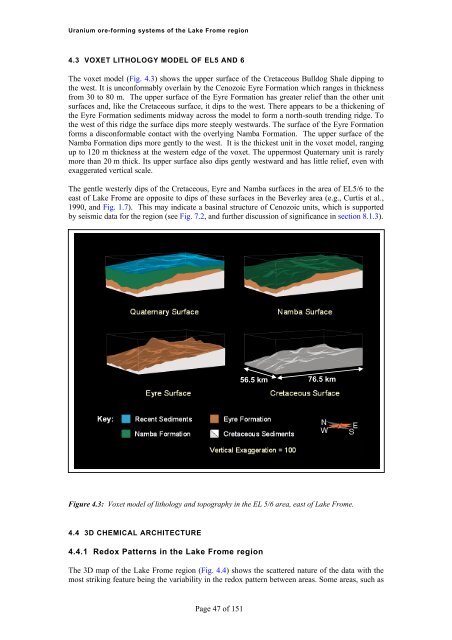
<strong>Uranium</strong> <strong>ore</strong>-<strong>forming</strong> <strong>systems</strong> <strong>of</strong> <strong>the</strong> Lake Frome region4.3 VOXET LITHOLOGY MODEL OF EL5 AND 6The voxet model (Fig. 4.3) shows <strong>the</strong> upper surface <strong>of</strong> <strong>the</strong> Cretaceous Bulldog Shale dipping to<strong>the</strong> west. It is unconformably overlain by <strong>the</strong> Cenozoic Eyre Formation which ranges in thicknessfrom 30 to 80 m. The upper surface <strong>of</strong> <strong>the</strong> Eyre Formation has greater relief than <strong>the</strong> o<strong>the</strong>r unitsurfaces and, like <strong>the</strong> Cretaceous surface, it dips to <strong>the</strong> west. There appears to be a thickening <strong>of</strong><strong>the</strong> Eyre Formation sediments midway across <strong>the</strong> model to form a north-south trending ridge. To<strong>the</strong> west <strong>of</strong> this ridge <strong>the</strong> surface dips m<strong>ore</strong> steeply westwards. The surface <strong>of</strong> <strong>the</strong> Eyre Formationforms a disconformable contact with <strong>the</strong> overlying Namba Formation. The upper surface <strong>of</strong> <strong>the</strong>Namba Formation dips m<strong>ore</strong> gently to <strong>the</strong> west. It is <strong>the</strong> thickest unit in <strong>the</strong> voxet model, rangingup to 120 m thickness at <strong>the</strong> western edge <strong>of</strong> <strong>the</strong> voxet. The uppermost Quaternary unit is rarelym<strong>ore</strong> than 20 m thick. Its upper surface also dips gently westward and has little relief, even wi<strong>the</strong>xaggerated vertical scale.The gentle westerly dips <strong>of</strong> <strong>the</strong> Cretaceous, Eyre and Namba surfaces in <strong>the</strong> area <strong>of</strong> EL5/6 to <strong>the</strong>east <strong>of</strong> Lake Frome are opposite to dips <strong>of</strong> <strong>the</strong>se surfaces in <strong>the</strong> Beverley area (e.g., Curtis et al.,1990, and Fig. 1.7). This may indicate a basinal structure <strong>of</strong> Cenozoic units, which is supportedby seismic data for <strong>the</strong> region (see Fig. 7.2, and fur<strong>the</strong>r discussion <strong>of</strong> significance in section 8.1.3).56.5 km76.5 kmFigure 4.3: Voxet model <strong>of</strong> lithology and topography in <strong>the</strong> EL 5/6 area, east <strong>of</strong> Lake Frome.4.4 3D CHEMICAL ARCHITECTURE4.4.1 Redox Patterns in <strong>the</strong> Lake Frome regionThe 3D map <strong>of</strong> <strong>the</strong> Lake Frome region (Fig. 4.4) shows <strong>the</strong> scattered nature <strong>of</strong> <strong>the</strong> data with <strong>the</strong>most striking feature being <strong>the</strong> variability in <strong>the</strong> redox pattern between areas. Some areas, such asPage 47 <strong>of</strong> 151


