

Uranium ore-forming systems of the - Geoscience Australia
Uranium ore-forming systems of the - Geoscience Australia
Uranium ore-forming systems of the - Geoscience Australia

Create successful ePaper yourself
Turn your PDF publications into a flip-book with our unique Google optimized e-Paper software.
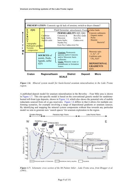
<strong>Uranium</strong> <strong>ore</strong>-<strong>forming</strong> <strong>systems</strong> <strong>of</strong> <strong>the</strong> Lake Frome regionPRESERVATION: Cenozoic age & lack <strong>of</strong> erosion; switch to dryer climate?TIMEE (Q4)NERGYTopographyRadiogenic granitesTectoniccompressionSOURCES <strong>of</strong>metals, fluids,ligands, sulfur(Q3)Fluid focussing: paleochannels; Poontana Inlier faultsPERMEABILITY (Q2, Q4):Cambrian Cenozoic & Beverley sandsbasin faults; Mesozoic Eyre FmAquifer units basin faults; Cadna-owieNamba Fm;Eyre Fm; Cadna-owie Fm<strong>Uranium</strong>: Proterozoicigneous and/or Cenozoicand/or Mesozoic basinsediments.Fluids: Meteoric water orgroundwater or formationwaters.Cenozoic sediments:Organic matterPyriteIlmeniteBacteria?Mesozoic seds:C, Fe 2+ , S 2-Cambrian seds:CH 4 , H 2 S?DEPOSITIONALGRADIENTS(Q5)Craton Regional/basin District Deposit MicroSCALEFigure 1.6: Mineral system model for basin-hosted uranium mineralisation in <strong>the</strong> Lake Fromeregion.A published deposit model for uranium mineralisation in <strong>the</strong> Beverley – Four Mile area is shownin Figure 1.7. This site-specific model is based on <strong>the</strong> conventional generic model for sandstonehostedroll-front type deposits, shown in Figure 1.8, which also shows <strong>the</strong> potential role <strong>of</strong> mobilereductants sourced from oil or gas reservoirs. Figure 1.6 differs in that it allows for multiple <strong>ore</strong><strong>forming</strong>scenarios, for example involving a range <strong>of</strong> depositional gradients or uranium sources.By identifying and mapping <strong>the</strong> mineral system components without bias towards any particularmodel we aim to generate new ‘search spaces’ for uranium exploration in <strong>the</strong> region.Figure 1.7: Schematic cross section <strong>of</strong> <strong>the</strong> Mt Painter Inlier - Lake Frome area, from Brugger et al.(2005).Page 9 <strong>of</strong> 151


