

Uranium ore-forming systems of the - Geoscience Australia
Uranium ore-forming systems of the - Geoscience Australia
Uranium ore-forming systems of the - Geoscience Australia

Create successful ePaper yourself
Turn your PDF publications into a flip-book with our unique Google optimized e-Paper software.
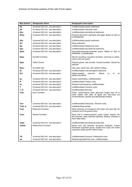
<strong>Uranium</strong> <strong>ore</strong>-<strong>forming</strong> <strong>systems</strong> <strong>of</strong> <strong>the</strong> Lake Frome regionMap Symbol Stratigraphic Name Stratigraphic DescriptionQe Unnamed GIS Unit - see description Undifferentiated aeolian sedimentsQh Unnamed GIS Unit - see description Undifferentiated Holocene rocksQha Unnamed GIS Unit - see description Undifferentiated alluvial/fluvial sedimentsQha4 Unnamed GIS Unit - see description Proximal alluvial fan sediments with gilgai. Based on Qh2 onCURNAMONAQhe Unnamed GIS Unit - see description Undifferentiated aeolian sedimentsQl1 Unnamed GIS Unit - see description Playa sedimentsQp Unnamed GIS Unit - see description Undifferentiated Pleistocene rocksQpa Unnamed GIS Unit - see description Undifferentiated alluvial/fluvial sedimentsQpa2 Unnamed GIS Unit - see description Gypcreted/carbonate-cemented gravel. Based on Qpt onWARRINA, CURDIMURKAQpae Eurinilla Formation Alluvial, lacustrine, lacustrine sh<strong>ore</strong>line. red-brown to yellowbrownsand and gravel.Qpat Telford Gravel Polymict gravel, well rounded, includes boulders. Alluvial fandeposits.Qpav Avondale Clay Clay, grey; sandy clay, with vertical mottling.Qr Unnamed GIS Unit - see description Undifferentiated colluvial/regolith sedimentsQr1 Unnamed GIS Unit - see description Gibber-mantled colluvium. Based on Q onMURLOOCOPPIEqz Unnamed GIS Unit - see description Quartz veins/bodies, undifferentiatedR Unnamed GIS Unit - see description Undifferentiated Triassic rockssh Unnamed GIS Unit - see description Sheared rocks/shearing, undifferentiatedT Unnamed GIS Unit - see description Undifferentiated Cenozoic rocksT_fe Unnamed GIS Unit - see description Undifferentiated ferricreteTaee Eyre Formation Pyritic, carbonaceous sand, grain-size ranges from silt tosmall cobble, with beds <strong>of</strong> lignite and clay.Clays aremontmorillonite, kaolinite and illite.Braided streams.Tam Unnamed GIS Unit - see description Undifferentiated Paleocene - Miocene rocksTmQ_si Unnamed GIS Unit - see description Undifferentiated silcreteTope Etadunna Formation White dolomite and limestone with green and grey Mg richclaystone and fine-grained sand.Topn Namba Formation Sand, fine to medium-grained, poorly sorted, angular, silt,thin dolomite, oolitic dolomite interbeds. Shallow, brackish t<strong>of</strong>resh water lakes.TpQa Unnamed GIS Unit - see description Undifferentiated alluvial/fluvial sedimentsTpQaw Willawortina Formation Sandy mud; silty dolomite, lacustrine, floodplain. Coarseframework supported gravel, braided flow origin and matrixsupported clayey gravels (debris flows).TQ Unnamed GIS Unit - see description Undifferentiated Cenozoic -Pleistocene rockswe Unnamed GIS Unit - see description Wea<strong>the</strong>ring/wea<strong>the</strong>red rocks, undifferentiatedPage 147 <strong>of</strong> 151


