Sam Ziemann From - Region of Waterloo
Sam Ziemann From - Region of Waterloo
Sam Ziemann From - Region of Waterloo
Create successful ePaper yourself
Turn your PDF publications into a flip-book with our unique Google optimized e-Paper software.
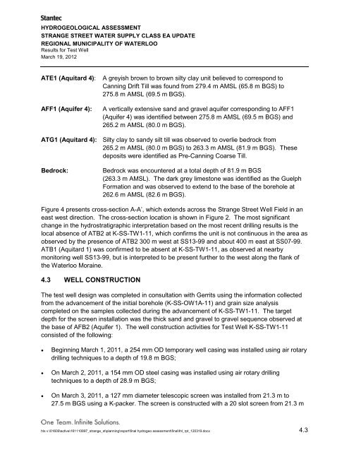
HYDROGEOLOGICAL ASSESSMENTSTRANGE STREET WATER SUPPLY CLASS EA UPDATEREGIONAL MUNICIPALITY OF WATERLOOResults for Test WellMarch 19, 2012ATE1 (Aquitard 4):AFF1 (Aquifer 4):A greyish brown to brown silty clay unit believed to correspond toCanning Drift Till was found from 279.4 m AMSL (65.8 m BGS) to275.8 m AMSL (69.5 m BGS).A vertically extensive sand and gravel aquifer corresponding to AFF1(Aquifer 4) was identified between 275.8 m AMSL (69.5 m BGS) and265.2 m AMSL (80.0 m BGS).ATG1 (Aquitard 4): Silty clay to sandy silt till was observed to overlie bedrock from265.2 m AMSL (80.0 m BGS) to 263.3 m AMSL (81.9 m BGS). Thesedeposits were identified as Pre-Canning Coarse Till.Bedrock:Bedrock was encountered at a total depth <strong>of</strong> 81.9 m BGS(263.3 m AMSL). The dark grey limestone was identified as the GuelphFormation and was observed to extend to the base <strong>of</strong> the borehole at262.6 m AMSL (82.6 m BGS).Figure 4 presents cross-section A-A’, which extends across the Strange Street Well Field in aneast west direction. The cross-section location is shown in Figure 2. The most significantchange in the hydrostratigraphic interpretation based on the most recent drilling results is thelocal absence <strong>of</strong> ATB2 at K-SS-TW1-11, which confirms the unit is not continuous in the area asobserved by the presence <strong>of</strong> ATB2 300 m west at SS13-99 and about 400 m east at SS07-99.ATB1 (Aquitard 1) was confirmed to be absent at K-SS-TW1-11, as observed at nearbymonitoring well SS13-99, but is interpreted to be present further to the west along the flank <strong>of</strong>the <strong>Waterloo</strong> Moraine.4.3 WELL CONSTRUCTIONThe test well design was completed in consultation with Gerrits using the information collectedfrom the advancement <strong>of</strong> the initial borehole (K-SS-OW1A-11) and grain size analysiscompleted on the samples collected during the advancement <strong>of</strong> K-SS-TW1-11. The targetdepth for the screen installation was the thick sand and gravel to gravel sequence observed atthe base <strong>of</strong> AFB2 (Aquifer 1). The well construction activities for Test Well K-SS-TW1-11consisted <strong>of</strong> the following:• Beginning March 1, 2011, a 254 mm OD temporary well casing was installed using air rotarydrilling techniques to a depth <strong>of</strong> 19.8 m BGS;• On March 2, 2011, a 154 mm OD steel casing was installed using air rotary drillingtechniques to a depth <strong>of</strong> 28.9 m BGS;• On March 3, 2011, a 127 mm diameter telescopic screen was installed from 21.3 m to27.5 m BGS using a K-packer. The screen is constructed with a 20 slot screen from 21.3 mhls v:\01609\active\161110897_strange_st\planning\report\final hydrogeo assessment\final\fnl_rpt_120319.docx 4.3


