

Marine Natural Values Study Summary - Parks Victoria
Marine Natural Values Study Summary - Parks Victoria
Marine Natural Values Study Summary - Parks Victoria

You also want an ePaper? Increase the reach of your titles
YUMPU automatically turns print PDFs into web optimized ePapers that Google loves.
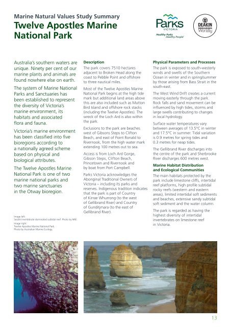
<strong>Marine</strong> <strong>Natural</strong> <strong>Values</strong> <strong>Study</strong> <strong>Summary</strong>Twelve Apostles <strong>Marine</strong>National ParkAustralia’s southern waters areunique. Ninety per cent of ourmarine plants and animals arefound nowhere else on earth.The system of <strong>Marine</strong> National<strong>Parks</strong> and Sanctuaries hasbeen established to representthe diversity of <strong>Victoria</strong>’smarine environment, itshabitats and associatedflora and fauna.<strong>Victoria</strong>’s marine environmenthas been classified into fivebioregions according toa nationally agreed schemebased on physical andbiological attributes.The Twelve Apostles <strong>Marine</strong>National Park is one of twomarine national parks andtwo marine sanctuariesin the Otway bioregion.Image left:Sessile invertebrate dominated subtidal reef. Photo by NRE.Image right:Twelve Apostles <strong>Marine</strong> National Park.Photo by Australian <strong>Marine</strong> Ecology.DescriptionThe park covers 7510 hectaresadjacent to Broken Head along thecoast to Pebble Point and offshoreto three nautical miles.Most of the Twelve Apostles <strong>Marine</strong>National Park begins at the high tidemark but additional land areas abovethis are also included such as MuttonBird Island and offshore rock stacks(including the Twelve Apostles). Thewreck of the Loch Ard is also withinthe park.Exclusions to the park are beacheswest of Gibsons Steps to CliftonBeach, and east of Point Ronald toRivernook, from the high water markextending 100 metres out to sea.Access is from Loch Ard Gorge,Gibson Steps, Clifton Beach,Princetown and Rivernook andby boat from Port Campbell.<strong>Parks</strong> <strong>Victoria</strong> acknowledges theAboriginal Traditional Owners of<strong>Victoria</strong> – including its parks andreserves. Indigenous tradition indicatesthat the park is part of Countryof Kirrae Whurrong (to the westof Gellibrand River) and Countryof Gunditjmara (to the east ofGellibrand River).Physical Parameters and ProcessesThe park is exposed to south-westerlywinds and swells of the SouthernOcean in winter and in spring/summerby those arising from Bass Strait in thesouth-east.The West Wind Drift creates a currentmoving easterly through the park.Rock falls and sand movement can beinfluenced by high tides, storms andlarge swells contributing to changesin local hydrology.Surface water temperatures varybetween averages of 13.5°C in winterand 17.5°C in summer. Tidal variationis 0.9 metres for spring tides and0.3 metres for neap tides.The Gellibrand River discharges intothe centre of the park and SherbrookeRiver discharges 600 metres west.<strong>Marine</strong> Habitat Distributionand Ecological CommunitiesThe main habitats protected by thepark include limestone cliffs, intertidalreef platforms, high profile subtidalrocky reefs (western and easternareas), limited intertidal soft sedimentsand beaches, extensive sandy subtidalsoft sediment and the water column.The park is regarded as having thehighest diversity of intertidalinvertebrates on limestone reefin <strong>Victoria</strong>.13


