

Marine Natural Values Study Summary - Parks Victoria
Marine Natural Values Study Summary - Parks Victoria
Marine Natural Values Study Summary - Parks Victoria

Create successful ePaper yourself
Turn your PDF publications into a flip-book with our unique Google optimized e-Paper software.
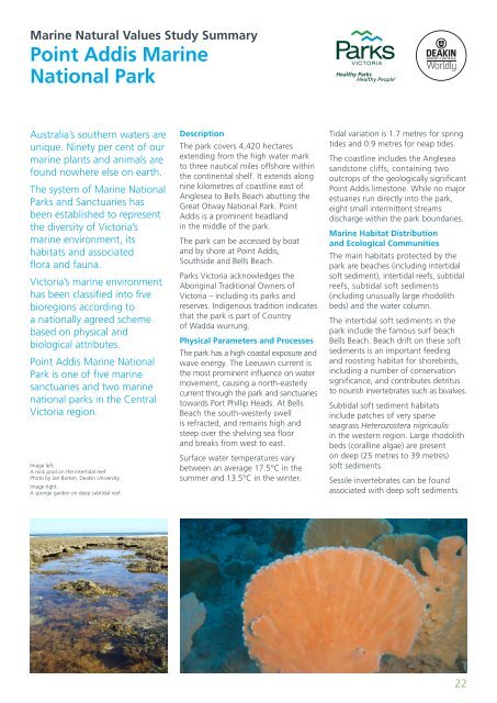
<strong>Marine</strong> <strong>Natural</strong> <strong>Values</strong> <strong>Study</strong> <strong>Summary</strong>Point Addis <strong>Marine</strong>National ParkAustralia’s southern waters areunique. Ninety per cent of ourmarine plants and animals arefound nowhere else on earth.The system of <strong>Marine</strong> National<strong>Parks</strong> and Sanctuaries hasbeen established to representthe diversity of <strong>Victoria</strong>’smarine environment, itshabitats and associatedflora and fauna.<strong>Victoria</strong>’s marine environmenthas been classified into fivebioregions according toa nationally agreed schemebased on physical andbiological attributes.Point Addis <strong>Marine</strong> NationalPark is one of five marinesanctuaries and two marinenational parks in the Central<strong>Victoria</strong> region.Image left:A rock pool on the intertidal reef.Photo by Jan Barton, Deakin University.Image right:A sponge garden on deep subtidal reef.DescriptionThe park covers 4,420 hectaresextending from the high water markto three nautical miles offshore withinthe continental shelf. It extends alongnine kilometres of coastline east ofAnglesea to Bells Beach abutting theGreat Otway National Park. PointAddis is a prominent headlandin the middle of the park.The park can be accessed by boatand by shore at Point Addis,Southside and Bells Beach.<strong>Parks</strong> <strong>Victoria</strong> acknowledges theAboriginal Traditional Owners of<strong>Victoria</strong> – including its parks andreserves. Indigenous tradition indicatesthat the park is part of Countryof Wadda wurrung.Physical Parameters and ProcessesThe park has a high coastal exposure andwave energy. The Leeuwin current isthe most prominent influence on watermovement, causing a north-easterlycurrent through the park and sanctuariestowards Port Phillip Heads. At BellsBeach the south-westerly swellis refracted, and remains high andsteep over the shelving sea floorand breaks from west to east.Surface water temperatures varybetween an average 17.5°C in thesummer and 13.5°C in the winter.Tidal variation is 1.7 metres for springtides and 0.9 metres for neap tides.The coastline includes the Angleseasandstone cliffs, containing twooutcrops of the geologically significantPoint Addis limestone. While no majorestuaries run directly into the park,eight small intermittent streamsdischarge within the park boundaries.<strong>Marine</strong> Habitat Distributionand Ecological CommunitiesThe main habitats protected by thepark are beaches (including intertidalsoft sediment), intertidal reefs, subtidalreefs, subtidal soft sediments(including unusually large rhodolithbeds) and the water column.The intertidal soft sediments in thepark include the famous surf beachBells Beach. Beach drift on these softsediments is an important feedingand roosting habitat for shorebirds,including a number of conservationsignificance, and contributes detritusto nourish invertebrates such as bivalves.Subtidal soft sediment habitatsinclude patches of very sparseseagrass Heterozostera nigricaulisin the western region. Large rhodolithbeds (coralline algae) are presenton deep (25 metres to 39 metres)soft sediments.Sessile invertebrates can be foundassociated with deep soft sediments22


