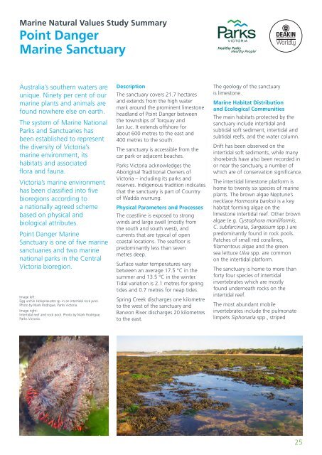
<strong>Marine</strong> <strong>Natural</strong> <strong>Values</strong> <strong>Study</strong> <strong>Summary</strong>Point Danger<strong>Marine</strong> SanctuaryAustralia’s southern waters areunique. Ninety per cent of ourmarine plants and animals arefound nowhere else on earth.The system of <strong>Marine</strong> National<strong>Parks</strong> and Sanctuaries hasbeen established to representthe diversity of <strong>Victoria</strong>’smarine environment, itshabitats and associatedflora and fauna.<strong>Victoria</strong>’s marine environmenthas been classified into fivebioregions according toa nationally agreed schemebased on physical andbiological attributes.Point Danger <strong>Marine</strong>Sanctuary is one of five marinesanctuaries and two marinenational parks in the Central<strong>Victoria</strong> bioregion.Image left:Egg urchin Holopneustes sp. in an intertidal rock pool.Photo by Mark Rodrigue, <strong>Parks</strong> <strong>Victoria</strong>.Image right:Intertidal reef and rock pool. Photo by Mark Rodrigue,<strong>Parks</strong> <strong>Victoria</strong>.DescriptionThe sanctuary covers 21.7 hectaresand extends from the high watermark around the prominent limestoneheadland of Point Danger betweenthe townships of Torquay andJan Juc. It extends offshore forabout 600 metres to the east and400 metres to the south.The sanctuary is accessible from thecar park or adjacent beaches.<strong>Parks</strong> <strong>Victoria</strong> acknowledges theAboriginal Traditional Owners of<strong>Victoria</strong> – including its parks andreserves. Indigenous tradition indicatesthat the sanctuary is part of Countryof Wadda wurrung.Physical Parameters and ProcessesThe coastline is exposed to strongwinds and large swell (mostly fromthe south and south west), andcurrents that are typical of opencoastal locations. The seafloor ispredominantly less than sevenmetres deep.Surface water temperatures varybetween an average 17.5 °C in thesummer and 13.5 °C in the winter.Tidal variation is 2.1 metres for springtides and 0.7 metres for neap tides.Spring Creek discharges one kilometreto the west of the sanctuary andBarwon River discharges 20 kilometresto the east.The geology of the sanctuaryis limestone.<strong>Marine</strong> Habitat Distributionand Ecological CommunitiesThe main habitats protected by thesanctuary include intertidal andsubtidal soft sediment, intertidal andsubtidal reefs, and the water column.Drift has been observed on theintertidal soft sediments, while manyshorebirds have also been recorded inor near the sanctuary, a number ofwhich are of conservation significance.The intertidal limestone platform ishome to twenty six species of marineplants. The brown algae Neptune’snecklace Hormosira banksii is a keyhabitat forming algae on thelimestone intertidal reef. Other brownalgae (e.g. Cystophora moniliformis,C. subfarcinata, Sargassum spp.) arepredominantly found in rock pools.Patches of small red corallines,filamentous algae and the greensea lettuce Ulva spp. are commonon the intertidal platform.The sanctuary is home to more thanforty four species of intertidalinvertebrates which are mostlyfound underneath rocks on theintertidal reef.The most abundant mobileinvertebrates include the pulmonatelimpets Siphonaria spp., striped25
conniwink Bembicium nanum and therugose slit limpet Clypidina rugosa.Mussel beds made up of the tinyhorse mussel Limnoperna pulex arealso common. The top shellChlorodiloma adelaidae can also beabundant hidden amongst rubble andunder stones. The predatorygastropods Lepsiella vinosa andDicathais orbita are often associatedwith Limnoperna pulex mussel beds.The turban shell Turbo undulatus andthe limpet Patelloida alticostata arepresent but in lower densities thanother molluscs.The shallow subtidal rocky reefs arehome to a mixture of brown algae,while extensive areas of the seagrassAmphibolis antarctica can be foundgrowing over reef and sedimentin the more sheltered areas.The sanctuary is particularlyrecognised for its diverse sea slug(opisthobranch) fauna found on bothintertidal and subtidal reefs withninety six species having beenrecorded, many of which are endemic.The water column is home to a varietyof planktonic and pelagic organisms.Those that make their permanenthome in the water column includesea jellies, salps, many fish, andphytoplankton and zooplankton.The water column is also foraginghabitat for several seabirds.Species and Communitiesof Conservation SignificanceThe sanctuary has eighteenconservation listed seabirds andshorebirds including three speciesof albatross (e.g. the wanderingalbatross Diomedea exulans), twospecies of tern (e.g. the Caspian ternHydroprogne caspia), two speciesof shearwater (e.g. sooty shearwaterArdenna grisea), the Pacific gull Laruspacificus, and the common divingpetrel Pelecanoides urinatrixamong others.The Point Danger <strong>Marine</strong> Sanctuaryis home to two biota that have beenrecorded or presumed to be at theirdistributional limit including one crabHexapus granuliferus and one marinesnail Tubercliopsis septapila, thoughthis may reflect collection effortin this area rather than actual<strong>Victoria</strong>n distributions.Major ThreatsMeasures to address or minimisethreats identified for Point Danger<strong>Marine</strong> Sanctuary form part of thepark management plan. <strong>Parks</strong> <strong>Victoria</strong>also uses an adaptive managementapproach which includes periodicreviews of priority natural values andthreats through processes such as theState of the <strong>Parks</strong> evaluation andsetting of desired conservationoutcomes. Through these processes<strong>Parks</strong> <strong>Victoria</strong> has identified emergingthreats and developed appropriatemanagement responses.Serious threats include marine pestsand pathogens, illegal harvesting,nutrients and heavy metals fromsewage outfall, man-made dischargesof freshwater and stormwater,trampling, disturbance throughrecreation (e.g. dogs, horses, vehicles),increased shore-based development,litter from land or sea, oil pollutionand impacts associated withshipwrecks (physical damage,pollution or cleanup impacts).The invasive Japanese kelp Undariapinnatifida has recently been foundin Apollo Bay Harbour and there areconcerns about its possible spread.Climate change also poses a seriousmedium to long term threat to naturalvalues. <strong>Parks</strong> <strong>Victoria</strong> will use anadaptive management approach todevelop responses and actions thatfocus on priority climate change issuessuch as extreme weather events andexisting risks that will likely beexacerbated by climate change.Research and Monitoring<strong>Parks</strong> <strong>Victoria</strong> has establishedextensive marine research andmonitoring programs that addressimportant management challenges forthe marine national parks andsanctuaries. These focus on improvingbaseline knowledge, as well as appliedmanagement questions.Since the establishment of the parksin 2002 our knowledge andunderstanding of natural valuesand threats for the system haveimproved significantly through themarine science program. Muchof the research has been undertakenas part of the Research PartnersProgram involving collaborationwith various research institutions.There are five ongoing researchprojects and one habitat mappingproject that are relevant to PointDanger <strong>Marine</strong> Sanctuary, while eightresearch projects and one habitatmapping project have already beencompleted. The sanctuary alsohas an ongoing intertidal reefmonitoring program.While recognising there are stillknowledge gaps <strong>Parks</strong> <strong>Victoria</strong> willcontinue to focus on addressingthe information needs that willassist management.For more information, includingmarine habitat mapping products,please see the full versions of the<strong>Marine</strong> <strong>Natural</strong> <strong>Values</strong> reportson www.parks.vic.gov.au.26