

Marine Natural Values Study Summary - Parks Victoria
Marine Natural Values Study Summary - Parks Victoria
Marine Natural Values Study Summary - Parks Victoria

You also want an ePaper? Increase the reach of your titles
YUMPU automatically turns print PDFs into web optimized ePapers that Google loves.
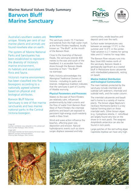
<strong>Marine</strong> <strong>Natural</strong> <strong>Values</strong> <strong>Study</strong> <strong>Summary</strong>Barwon Bluff<strong>Marine</strong> SanctuaryAustralia’s southern waters areunique. Ninety per cent of ourmarine plants and animals arefound nowhere else on earth.The system of <strong>Marine</strong> National<strong>Parks</strong> and Sanctuaries hasbeen established to representthe diversity of <strong>Victoria</strong>’smarine environment,its habitats and associatedflora and fauna.<strong>Victoria</strong>’s marine environmenthas been classified into fivebioregions according to anationally agreed schemebased on physical andbiological attributes.Barwon Bluff <strong>Marine</strong>Sanctuary is one of five marinesanctuaries and two marinenational parks in the Central<strong>Victoria</strong> bioregion.Image left:Southern rocklobster Jasus edwardsii on the subtidal reef.Photo by Mark Rodrigue, <strong>Parks</strong> <strong>Victoria</strong>.Image right:Submerged intertidal reef dominated by the brown algaeNeptune’s necklace Hormosira banksii.Photo by Mark Rodrigue, <strong>Parks</strong> <strong>Victoria</strong>.DescriptionThe sanctuary covers 15.7 hectaresand extends from the high water markat the Point Flinders headland, locallyknown as “The Bluff” at the mouthof the Barwon River.Close to the township of BarwonHeads, the sanctuary extends 400metres to the east and south of theheadland. It is accessible from theshore through the Barwon Headstownship or from “The Bluff”via stairways.<strong>Parks</strong> <strong>Victoria</strong> acknowledges theAboriginal Traditional Owners of<strong>Victoria</strong> – including its parks andreserves. Indigenous tradition indicatesthat the sanctuary is part of Countryof Wadda wurrung.Physical Parameters and ProcessesWaters to the east of Point Flindersare relatively calm, influencedpredominantly by tidal currents andthe flow of water from Barwon River.West of Point Flinders the intertidalplatforms and beach are exposed topersistent high-energy south-westerlyswells in Bass Strait.Wind and wave action influence thebeaches, affecting grain size,deposition and erosion. <strong>Natural</strong>hydrodynamic events such as stormsurges displace seaweed and kelpcommunities, erode beaches anddeposit sand over the reefs.Surface water temperatures varybetween an average 17.5°C in thesummer and 13.5°C in the winter.Tidal variation is 2.1 metres for springtides and 0.7 metres for neap tides.The Barwon River estuary runs intoBass Strait 600 metres north ofthe sanctuary. Barwon Heads isgeologically significant as a coastalbluff in Pleistocene dune calcarenitewith interbedded palaeosoils, restingon basalt.<strong>Marine</strong> Habitat Distributionand Ecological CommunitiesThe main habitats protected by thesanctuary include intertidal andsubtidal soft sediment, intertidal andsubtidal reefs, and the water column.The intertidal calcarenite and basaltreef is home to a variety of marineplants. The brown algae Neptune’snecklace Hormosira banksii is a keyhabitat forming plant on theseintertidal reefs. Other brown algae(e.g. Cystophora retorta, C. retroflexa)are largely found very low on theshore or in rock pools. The seagrassAmphibolis antarctica can also befound in rock pools.Large patches of the red turfing algaeCapreolia implexa can have very high27


