

Marine Natural Values Study Summary - Parks Victoria
Marine Natural Values Study Summary - Parks Victoria
Marine Natural Values Study Summary - Parks Victoria

You also want an ePaper? Increase the reach of your titles
YUMPU automatically turns print PDFs into web optimized ePapers that Google loves.
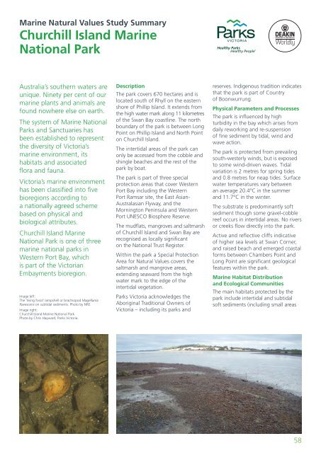
<strong>Marine</strong> <strong>Natural</strong> <strong>Values</strong> <strong>Study</strong> <strong>Summary</strong>Churchill Island <strong>Marine</strong>National ParkAustralia’s southern waters areunique. Ninety per cent of ourmarine plants and animals arefound nowhere else on earth.The system of <strong>Marine</strong> National<strong>Parks</strong> and Sanctuaries hasbeen established to representthe diversity of <strong>Victoria</strong>’smarine environment, itshabitats and associatedflora and fauna.<strong>Victoria</strong>’s marine environmenthas been classified into fivebioregions according toa nationally agreed schemebased on physical andbiological attributes.Churchill Island <strong>Marine</strong>National Park is one of threemarine national parks inWestern Port Bay, whichis part of the <strong>Victoria</strong>nEmbayments bioregion.Image left:The ‘living fossil’ lampshell or brachiopod Magellaniaflavescens on subtidal sediments. Photo by NRE.Image right:Churchill Island <strong>Marine</strong> National Park.Photo by Chris Hayward, <strong>Parks</strong> <strong>Victoria</strong>.DescriptionThe park covers 670 hectares and islocated south of Rhyll on the easternshore of Phillip Island. It extends fromthe high water mark along 11 kilometresof the Swan Bay coastline. The northboundary of the park is between LongPoint on Phillip Island and North Pointon Churchill Island.The intertidal areas of the park canonly be accessed from the cobble andshingle beaches and the rest of thepark by boat.The park is part of three specialprotection areas that cover WesternPort Bay including the WesternPort Ramsar site, the East Asian-Australasian Flyway, and theMornington Peninsula and WesternPort UNESCO Biosphere Reserve.The mudflats, mangroves and saltmarshof Churchill Island and Swan Bay arerecognised as locally significanton the National Trust Register.Within the park a Special ProtectionArea for <strong>Natural</strong> <strong>Values</strong> covers thesaltmarsh and mangrove areas,extending seaward from the highwater mark to the edge of theintertidal vegetation.<strong>Parks</strong> <strong>Victoria</strong> acknowledges theAboriginal Traditional Owners of<strong>Victoria</strong> – including its parks andreserves. Indigenous tradition indicatesthat the park is part of Countryof Boonwurrung.Physical Parameters and ProcessesThe park is influenced by highturbidity in the bay which arises fromdaily reworking and re-suspensionof fine sediment by tidal, wind andwave action.The park is protected from prevailingsouth-westerly winds, but is exposedto some wind-driven waves. Tidalvariation is 2 metres for spring tidesand 0.8 metres for neap tides. Surfacewater temperatures vary betweenan average 20.4°C in the summerand 11.7°C in the winter.The substrate is predominantly softsediment though some gravel-cobblereef occurs in intertidal areas. No riversor creeks flow directly into the park.Active and reflective cliffs indicativeof higher sea levels at Swan Corner,and raised beach and emerged coastalforms between Chambers Point andLong Point are significant geologicalfeatures within the park.<strong>Marine</strong> Habitat Distributionand Ecological CommunitiesThe main habitats protected by thepark include intertidal and subtidalsoft sediments (including small areas58


