

Marine Natural Values Study Summary - Parks Victoria
Marine Natural Values Study Summary - Parks Victoria
Marine Natural Values Study Summary - Parks Victoria

You also want an ePaper? Increase the reach of your titles
YUMPU automatically turns print PDFs into web optimized ePapers that Google loves.
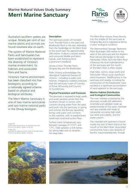
<strong>Marine</strong> <strong>Natural</strong> <strong>Values</strong> <strong>Study</strong> <strong>Summary</strong>Merri <strong>Marine</strong> SanctuaryAustralia’s southern waters areunique. Ninety per cent of ourmarine plants and animals arefound nowhere else on earth.The system of <strong>Marine</strong> National<strong>Parks</strong> and Sanctuaries hasbeen established to representthe diversity of <strong>Victoria</strong>’smarine environment, itshabitats and associatedflora and fauna.<strong>Victoria</strong>’s marine environmenthas been classified into fivebioregions according toa nationally agreed schemebased on physical andbiological attributes.The Merri <strong>Marine</strong> Sanctuary isone of two marine sanctuariesand two marine national parksin the Otway bioregion.Image left:Diverse algal community in an intertidal rock pool.Photo by Jan Barton, Deakin University.Image right:Intertidal soft sediment at the mouth of the Merri River.Photo by Jan Barton, Deakin University.DescriptionThe sanctuary covers 29 hectaresfrom Thunder Point in the west andBreakwater Rock in the east, extendingfrom the footbridge on the Merri Riverto the south-west for approximately200 metres. It abuts a coastal reserveand surrounds Middle and MerriIslands, with Pickering Pointa prominent headland.Access is from Thunder Point,Stingray Bay and the Breakwater.<strong>Parks</strong> <strong>Victoria</strong> acknowledges theAboriginal Traditional Owners of<strong>Victoria</strong> – including its parks andreserves. Indigenous tradition indicatesthat the sanctuary is part of Countryof Kirrae Whurrong and Countryof Gunditjmara.Physical Parameters and ProcessesThe sanctuary is exposed to large swellsand south-westerly winds from theSouthern Ocean in winter, withcurrents carrying water from the westand south into the sanctuary. In springand summer the Bonney Upwellingbrings cold water and nutrientsto the coastline, with its predominantsouth-east wind and current flow.Surface water temperatures varybetween averages of 13.5°C and17°C. Tidal variation is 0.8 metresfor spring tides and no variationfor neap tides.The Merri River estuary flows directlyinto the middle of the sanctuary atStingray Bay and is regarded as beingin poor ecological condition.The Warrnambool Sewage TreatmentPlant discharges 500 metres to thewest of the sanctuary and the HopkinsRiver estuary discharges to the east.Freshwater inflow from the Merri Riverinfluences the local hydrodynamicsof the sanctuary and the mouthof the Merri River is often closed.High tides, storms, large swells andfreshwater inflow cause significantsand movement. Modifications in thesanctuary and nearby, including theconstruction of the breakwater, haveresulted in a significant accumulationof sand adjacent to the sanctuary.<strong>Marine</strong> Habitat Distributionand Ecological CommunitiesThe main habitats protected by thesanctuary include soft sediments(intertidal and subtidal) made uppredominantly of fine sand; intertidalreef and subtidal reef made ofcalcarenite including high relief,low relief and cobbles; and thewater column.The intertidal soft sediment is foundmostly the east of Merri Island at themouth of the Merri River. Associatedcommunities have a low diversity ofbenthic macroinvertebrates, though8


