

Marine Natural Values Study Summary - Parks Victoria
Marine Natural Values Study Summary - Parks Victoria
Marine Natural Values Study Summary - Parks Victoria

Create successful ePaper yourself
Turn your PDF publications into a flip-book with our unique Google optimized e-Paper software.
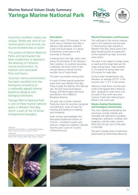
<strong>Marine</strong> <strong>Natural</strong> <strong>Values</strong> <strong>Study</strong> <strong>Summary</strong>Yaringa <strong>Marine</strong> National ParkAustralia’s southern waters areunique. Ninety per cent of ourmarine plants and animals arefound nowhere else on earth.The system of <strong>Marine</strong> National<strong>Parks</strong> and Sanctuaries hasbeen established to representthe diversity of <strong>Victoria</strong>’smarine environment, itshabitats and associatedflora and fauna.<strong>Victoria</strong>’s marine environmenthas been classified into fivebioregions according toa nationally agreed schemebased on physical andbiological attributes.Yaringa <strong>Marine</strong> National Parkis one of three marine nationalparks in Western Port Bay,which is part of the <strong>Victoria</strong>nEmbayments bioregion.Image left:Periwinkle Austrocochlea sp. on submerged mangroveleaves. Photo by Julian Finn, Museum <strong>Victoria</strong>.Image right:Intertidal bare sediment and mangroves in Yaringa <strong>Marine</strong>National Park. Photo by Adam Pope, Deakin University.DescriptionThe park covers 776 hectares, in thenorth west of Western Port Bay inWatsons Inlet between WatsonsCreek and Quail Island. It is about9 kilometres south-west of thetownship of Tooradin.It extends from the high water markalong 20 kilometres of the WatsonsInlet coastline. Its southern boundaryis between the shore north of theYaringa Marina channel and thesouthern tip of Quail Island.The park is accessible only by boat.It is part of three special protectionareas that cover Western Port Bay.These include the Western Port Ramsarsite, the East Asian-AustralasianFlyway, and Mornington Peninsulaand Western Port UNESCOBiosphere Reserve.The park also includes a SpecialProtection Area for sensitive mangroveand saltmarsh, areas of value forroosting and feeding for seabirdsand shorebirds.<strong>Parks</strong> <strong>Victoria</strong> acknowledges theAboriginal Traditional Owners of<strong>Victoria</strong> – including its parks andreserves. Indigenous tradition indicatesthat the park is part of Countryof Boonwurrung.Physical Parameters and ProcessesThe substrate in the marine nationalpark is soft sediment and the parkis influenced by high turbidity inWestern Port Bay, which arises fromdaily reworking and re-suspensionof fine sediment by tidal, wind andwave action.The park is not subject to large wavesor swell and the large tides are themajor driving force. Tidal variationis 2.6 metres for spring tides and0.9 metres for neap tides.Surface water temperatures varybetween an average 20.5°C in thesummer and 11.5°C in the winter.Watsons Creek flows into the parknorth of Bungower Rd in WatsonsInlet. Langwarrin Creek flows intothe park in the north-west andCannon Creek from behind QuailIsland in the north east.<strong>Marine</strong> Habitat Distributionand Ecological CommunitiesThe main habitats protected by thesanctuary include subtidal andintertidal soft sediments (includingmangroves, saltmarsh, mudflats andseagrass), and the water column.More than 82 per cent of the parkis intertidal.The park includes areas of saltmarsh(dominated by Tetricornia arbuscula52


