

Marine Natural Values Study Summary - Parks Victoria
Marine Natural Values Study Summary - Parks Victoria
Marine Natural Values Study Summary - Parks Victoria

Create successful ePaper yourself
Turn your PDF publications into a flip-book with our unique Google optimized e-Paper software.
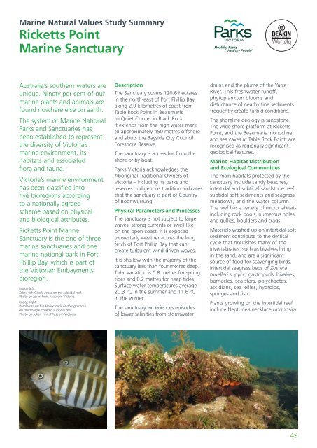
<strong>Marine</strong> <strong>Natural</strong> <strong>Values</strong> <strong>Study</strong> <strong>Summary</strong>Ricketts Point<strong>Marine</strong> SanctuaryAustralia’s southern waters areunique. Ninety per cent of ourmarine plants and animals arefound nowhere else on earth.The system of <strong>Marine</strong> National<strong>Parks</strong> and Sanctuaries hasbeen established to representthe diversity of <strong>Victoria</strong>’smarine environment, itshabitats and associatedflora and fauna.<strong>Victoria</strong>’s marine environmenthas been classified intofive bioregions accordingto a nationally agreedscheme based on physicaland biological attributes.Ricketts Point <strong>Marine</strong>Sanctuary is the one of threemarine sanctuaries and onemarine national park in PortPhillip Bay, which is part ofthe <strong>Victoria</strong>n Embaymentsbioregion.Image left:Zebra fish Girella zebra on the subtidal reef.Photo by Julian Finn, Museum <strong>Victoria</strong>.Image right:Purple sea urchin Heliocidaris erythrogrammaon macroalgal covered subtidal reef.Photo by Julian Finn, Museum <strong>Victoria</strong>.DescriptionThe Sanctuary covers 120.6 hectaresin the north-east of Port Phillip Bayalong 2.9 kilometres of coast fromTable Rock Point in Beaumaristo Quiet Corner in Black Rock.It extends from the high water markto approximately 450 metres offshoreand abuts the Bayside City CouncilForeshore Reserve.The sanctuary is accessible from theshore or by boat.<strong>Parks</strong> <strong>Victoria</strong> acknowledges theAboriginal Traditional Owners of<strong>Victoria</strong> – including its parks andreserves. Indigenous tradition indicatesthat the sanctuary is part of Countryof Boonwurrung.Physical Parameters and ProcessesThe sanctuary is not subject to largewaves, strong currents or swell likeon the open coast, it is exposedto westerly weather across the longfetch of Port Phillip Bay that cancreate turbulent wind-driven waves.It is shallow with the majority of thesanctuary less than four metres deep.Tidal variation is 0.8 metres for springtides and 0.2 metres for neap tides.Surface water temperatures average20.3 °C in the summer and 11.6 °Cin the winter.The sanctuary experiences episodesof lower salinities from stormwaterdrains and the plume of the YarraRiver. This freshwater runoff,phytoplankton blooms anddisturbance of nearby fine sedimentsfrequently create turbid conditions.The shoreline geology is sandstone.The wide shore platform at RickettsPoint, and the Beaumaris monoclineand sea caves at Table Rock Point, arerecognised as regionally significantgeological features.<strong>Marine</strong> Habitat Distributionand Ecological CommunitiesThe main habitats protected by thesanctuary include sandy beaches,intertidal and subtidal sandstone reef,subtidal soft sediments and seagrassmeadows, and the water column.The reef has a variety of microhabitatsincluding rock pools, numerous holesand gullies, boulders and crags.Materials washed up on intertidal softsediment contribute to the detritalcycle that nourishes many of theinvertebrates, such as bivalves livingin the sand, and are a significantsource of food for scavenging birds.Intertidal seagrass beds of Zosteramuelleri support gastropods, bivalves,barnacles, sea stars, polychaetes,ascidians, sea jellies, hydroids,sponges and fish.Plants growing on the intertidal reefinclude Neptune’s necklace Hormosira49


