

Marine Natural Values Study Summary - Parks Victoria
Marine Natural Values Study Summary - Parks Victoria
Marine Natural Values Study Summary - Parks Victoria

You also want an ePaper? Increase the reach of your titles
YUMPU automatically turns print PDFs into web optimized ePapers that Google loves.
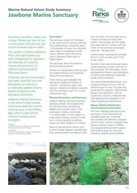
<strong>Marine</strong> <strong>Natural</strong> <strong>Values</strong> <strong>Study</strong> <strong>Summary</strong>Jawbone <strong>Marine</strong> SanctuaryAustralia’s southern waters areunique. Ninety per cent of ourmarine plants and animals arefound nowhere else on earth.The system of <strong>Marine</strong> National<strong>Parks</strong> and Sanctuaries hasbeen established to representthe diversity of <strong>Victoria</strong>’smarine environment, itshabitats and associatedflora and fauna.<strong>Victoria</strong>’s marine environmenthas been classified into fivebioregions according toa nationally agreed schemebased on physical andbiological attributes.Jawbone <strong>Marine</strong> Sanctuaryis the one of three marinesanctuaries and one marinenational park in Port PhillipBay, which is part of the<strong>Victoria</strong>n Embaymentsbioregion.Image left:Intertidal basalt reef in Jawbone <strong>Marine</strong> Sanctuary.Photo by Australian <strong>Marine</strong> Ecology.Image right:The hard coral Plesiastrea versipora on subtidal reef.Photo by Australian <strong>Marine</strong> Ecology.DescriptionThe sanctuary covers 30.5 hectaresin the north-west of the bay, offshorefrom Williamstown. It extends along1.9 kilometres of coast from the highwater mark to a maximum of 300metres offshore, from the fishingclubs in Bayview Street west toWader Beach.The sanctuary abuts the JawboneFlora and Fauna reserve.Access is on designated walking tracksvia Jawbone Reserve and JawboneFlora and Fauna Reserve.<strong>Parks</strong> <strong>Victoria</strong> acknowledges theAboriginal Traditional Owners of<strong>Victoria</strong> – including its parks andreserves. Indigenous tradition indicatesthat the sanctuary is part of Countryof Boonwurrung.Physical Parameters and ProcessesJawbone <strong>Marine</strong> Sanctuary shorelinegeology is basalt, the seaward endof lava flows that characterizeMelbourne’s western plains. Thesanctuary is shallow and mostly< 4 metres deep. It is not subject tolarge waves, strong currents or swellbut in strong westerly conditionswaves can reach heights of 2 metres.<strong>Natural</strong> hydrodynamic events suchas storm surges displace seaweed andkelp, erode beaches and deposit sandover the reefs. The sanctuary has anunequal semidiurnal daily tidalpattern. Spring tides are 0.8 metresand neap tides 0.2 metres, with thewater in the sanctuary exchangedevery 28 – 50 tidal cycles.Surface water temperatures average20.4°C in the summer and 11.6°Cin the winter.Kororoit Creek and stormwater drainscreate episodes of lower salinities inthe sanctuary. This freshwater runoff,phytoplankton blooms and disturbanceof nearby fine sediments frequentlycreate turbid conditions.The former Merrett Rifle Range, nowa Special Protection Area, with itslimited access for over 110 years hasprotected this shoreline. Merrett RifleRange shore platform, with itsQuaternary volcanics, intertidal reef,shell deposits and mangroves is ofregional geological significance.<strong>Marine</strong> Habitat Distributionand Ecological CommunitiesThe main habitats protected by thesanctuary include intertidal andsubtidal basalt reef, intertidaland subtidal soft sediment, seagrassand the water column. Its basalt reefs,shallow inshore waters, mudflatsand seagrass beds provide foragingand roosting areas for local andmigratory seabirds and shorebirds.46


