

Marine Natural Values Study Summary - Parks Victoria
Marine Natural Values Study Summary - Parks Victoria
Marine Natural Values Study Summary - Parks Victoria

You also want an ePaper? Increase the reach of your titles
YUMPU automatically turns print PDFs into web optimized ePapers that Google loves.
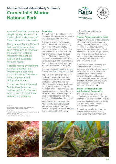
<strong>Marine</strong> <strong>Natural</strong> <strong>Values</strong> <strong>Study</strong> <strong>Summary</strong>Corner Inlet <strong>Marine</strong>National ParkAustralia’s southern waters areunique. Ninety per cent of ourmarine plants and animals arefound nowhere else on earth.The system of <strong>Marine</strong> National<strong>Parks</strong> and Sanctuaries hasbeen established to representthe diversity of <strong>Victoria</strong>’smarine environment, itshabitats and associatedflora and fauna.<strong>Victoria</strong>’s marine environmenthas been classified intofive bioregions accordingto a nationally agreed schemebased on physical andbiological attributes.Corner Inlet <strong>Marine</strong> NationalPark is the only marinenational park in Corner Inlet,which is part of the <strong>Victoria</strong>nEmbayments bioregion.Image left:Solitary corals Culicia australiensis on subtidal reef.Photo by Julian Finn, Museum <strong>Victoria</strong>.Image right:Potbellied seahorse Hippocampus abdominalis in Posidoniaaustralis seagrass bed.Photo by Mark Norman, Museum <strong>Victoria</strong>.DescriptionThe park covers 1,333 hectares andcomprises two separate sections in thesouth-east coast of Corner Inlet.The northern section of the parkextends west from near White DogPoint to a point approximately6 kilometres offshore and then backto the shore at Tin Mine Cove. Thenear shore areas include the deepwaters of Bennison Channel. Thesouthern section extends west fromthe southern part of Chinaman LongBeach to Bennison Island, and fromBennison Island south to Barry Hill.It can be accessed by boat, or on footfrom Wilsons Promontory National Park.The park forms part of an area thathas been recognised as a wetlandof international significance underthe Ramsar Convention. It is partof the East Asian-Australasian Flywayfor migratory waders. A specialProtection Area – <strong>Natural</strong> <strong>Values</strong> Areamanagement overlay covers the parkexcept Bennison Channel, to protectthe significant seagrass beds andwading bird habitats from disturbance.<strong>Parks</strong> <strong>Victoria</strong> acknowledges theAboriginal Traditional Owners of<strong>Victoria</strong> – including its parks andreserves. Indigenous tradition indicatesthat the park is part of Countryof Gunai/Kurnai and Countryof Boonwurrung.Physical Parameters and ProcessesThe park is influenced by tidal variationswhich are further complicated bychanges in wind speed and direction,high and low pressure systems,wave action and storm surges. Tidalvariation is 2.1 metres for spring tidesand 1 metre for neap tides. Surfacewater temperatures vary betweenan average 20°C in the summerand 12°C in the winter.The substrate is predominantly softsediment though a regionallysignificant area of weathered graniteshore platform and active granitesand spit development occursbetween Barry Hill and BennisonPoint. Direct discharges into the parkinclude Chinaman Creek and severalintermittent creeks from WilsonsPromontory National Park.<strong>Marine</strong> Habitat Distributionand Ecological CommunitiesThe park protects a wide varietyof marine habitats ranging from deepchannels to extensive shallow seagrassbeds, tidal sand and mud flats, sandybeaches, and some rocky reefs,mangroves and saltmarsh.The park is especially significant forover-wintering migratory wadingbirds, supporting up to 50 per cent61


