

Marine Natural Values Study Summary - Parks Victoria
Marine Natural Values Study Summary - Parks Victoria
Marine Natural Values Study Summary - Parks Victoria

You also want an ePaper? Increase the reach of your titles
YUMPU automatically turns print PDFs into web optimized ePapers that Google loves.
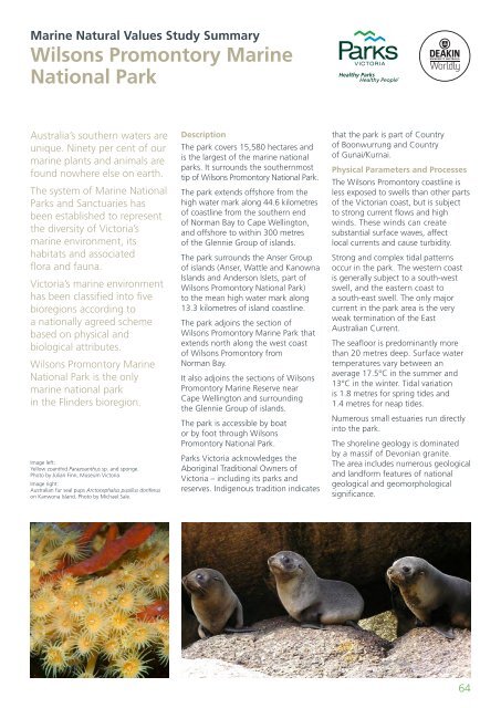
<strong>Marine</strong> <strong>Natural</strong> <strong>Values</strong> <strong>Study</strong> <strong>Summary</strong>Wilsons Promontory <strong>Marine</strong>National ParkAustralia’s southern waters areunique. Ninety per cent of ourmarine plants and animals arefound nowhere else on earth.The system of <strong>Marine</strong> National<strong>Parks</strong> and Sanctuaries hasbeen established to representthe diversity of <strong>Victoria</strong>’smarine environment, itshabitats and associatedflora and fauna.<strong>Victoria</strong>’s marine environmenthas been classified into fivebioregions according toa nationally agreed schemebased on physical andbiological attributes.Wilsons Promontory <strong>Marine</strong>National Park is the onlymarine national parkin the Flinders bioregion.Image left:Yellow zoanthid Parazoanthus sp. and sponge.Photo by Julian Finn, Museum <strong>Victoria</strong>.Image right:Australian fur seal pups Arctocephalus pusillus doriferuson Kanwona Island. Photo by Michael Sale.DescriptionThe park covers 15,580 hectares andis the largest of the marine nationalparks. It surrounds the southernmosttip of Wilsons Promontory National Park.The park extends offshore from thehigh water mark along 44.6 kilometresof coastline from the southern endof Norman Bay to Cape Wellington,and offshore to within 300 metresof the Glennie Group of islands.The park surrounds the Anser Groupof islands (Anser, Wattle and KanownaIslands and Anderson Islets, part ofWilsons Promontory National Park)to the mean high water mark along13.3 kilometres of island coastline.The park adjoins the section ofWilsons Promontory <strong>Marine</strong> Park thatextends north along the west coastof Wilsons Promontory fromNorman Bay.It also adjoins the sections of WilsonsPromontory <strong>Marine</strong> Reserve nearCape Wellington and surroundingthe Glennie Group of islands.The park is accessible by boator by foot through WilsonsPromontory National Park.<strong>Parks</strong> <strong>Victoria</strong> acknowledges theAboriginal Traditional Owners of<strong>Victoria</strong> – including its parks andreserves. Indigenous tradition indicatesthat the park is part of Countryof Boonwurrung and Countryof Gunai/Kurnai.Physical Parameters and ProcessesThe Wilsons Promontory coastline isless exposed to swells than other partsof the <strong>Victoria</strong>n coast, but is subjectto strong current flows and highwinds. These winds can createsubstantial surface waves, affectlocal currents and cause turbidity.Strong and complex tidal patternsoccur in the park. The western coastis generally subject to a south-westswell, and the eastern coast toa south-east swell. The only majorcurrent in the park area is the veryweak termination of the EastAustralian Current.The seafloor is predominantly morethan 20 metres deep. Surface watertemperatures vary between anaverage 17.5°C in the summer and13°C in the winter. Tidal variationis 1.8 metres for spring tides and1.4 metres for neap tides.Numerous small estuaries run directlyinto the park.The shoreline geology is dominatedby a massif of Devonian granite.The area includes numerous geologicaland landform features of nationalgeological and geomorphologicalsignificance.64


