

Marine Natural Values Study Summary - Parks Victoria
Marine Natural Values Study Summary - Parks Victoria
Marine Natural Values Study Summary - Parks Victoria

Create successful ePaper yourself
Turn your PDF publications into a flip-book with our unique Google optimized e-Paper software.
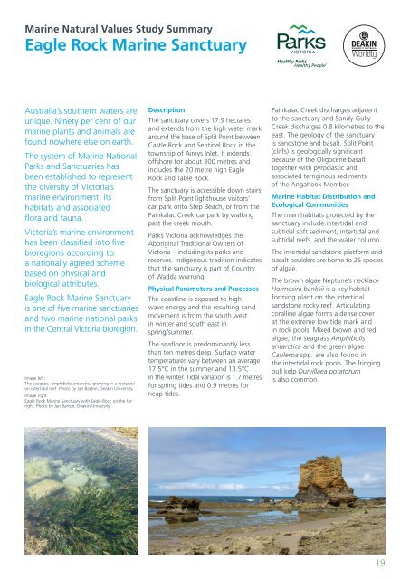
<strong>Marine</strong> <strong>Natural</strong> <strong>Values</strong> <strong>Study</strong> <strong>Summary</strong>Eagle Rock <strong>Marine</strong> SanctuaryAustralia’s southern waters areunique. Ninety per cent of ourmarine plants and animals arefound nowhere else on earth.The system of <strong>Marine</strong> National<strong>Parks</strong> and Sanctuaries hasbeen established to representthe diversity of <strong>Victoria</strong>’smarine environment, itshabitats and associatedflora and fauna.<strong>Victoria</strong>’s marine environmenthas been classified into fivebioregions according toa nationally agreed schemebased on physical andbiological attributes.Eagle Rock <strong>Marine</strong> Sanctuaryis one of five marine sanctuariesand two marine national parksin the Central <strong>Victoria</strong> bioregion.Image left:The seagrass Amphibolis antarctica growing in a rockpoolon intertidal reef. Photo by Jan Barton, Deakin University.Image right:Eagle Rock <strong>Marine</strong> Sanctuary with Eagle Rock on the farright. Photo by Jan Barton, Deakin University.DescriptionThe sanctuary covers 17.9 hectaresand extends from the high water markaround the base of Split Point betweenCastle Rock and Sentinel Rock in thetownship of Aireys Inlet. It extendsoffshore for about 300 metres andincludes the 20 metre high EagleRock and Table Rock.The sanctuary is accessible down stairsfrom Split Point lighthouse visitors’car park onto Step Beach, or from thePainkalac Creek car park by walkingpast the creek mouth.<strong>Parks</strong> <strong>Victoria</strong> acknowledges theAboriginal Traditional Owners of<strong>Victoria</strong> – including its parks andreserves. Indigenous tradition indicatesthat the sanctuary is part of Countryof Wadda wurrung.Physical Parameters and ProcessesThe coastline is exposed to highwave energy and the resulting sandmovement is from the south westin winter and south east inspring/summer.The seafloor is predominantly lessthan ten metres deep. Surface watertemperatures vary between an average17.5°C in the summer and 13.5°Cin the winter. Tidal variation is 1.7 metresfor spring tides and 0.9 metres forneap tides.Painkalac Creek discharges adjacentto the sanctuary and Sandy GullyCreek discharges 0.8 kilometres to theeast. The geology of the sanctuaryis sandstone and basalt. Split Point(cliffs) is geologically significantbecause of the Oligocene basalttogether with pyroclastic andassociated terriginous sedimentsof the Angahook Member.<strong>Marine</strong> Habitat Distribution andEcological CommunitiesThe main habitats protected by thesanctuary include intertidal andsubtidal soft sediment, intertidal andsubtidal reefs, and the water column.The intertidal sandstone platform andbasalt boulders are home to 25 speciesof algae.The brown algae Neptune’s necklaceHormosira banksii is a key habitatforming plant on the intertidalsandstone rocky reef. Articulatingcoralline algae forms a dense coverat the extreme low tide mark andin rock pools. Mixed brown and redalgae, the seagrass Amphibolisantarctica and the green algaeCaulerpa spp. are also found inthe intertidal rock pools. The fringingbull kelp Durvillaea potatorumis also common.19


