

Marine Natural Values Study Summary - Parks Victoria
Marine Natural Values Study Summary - Parks Victoria
Marine Natural Values Study Summary - Parks Victoria

Create successful ePaper yourself
Turn your PDF publications into a flip-book with our unique Google optimized e-Paper software.
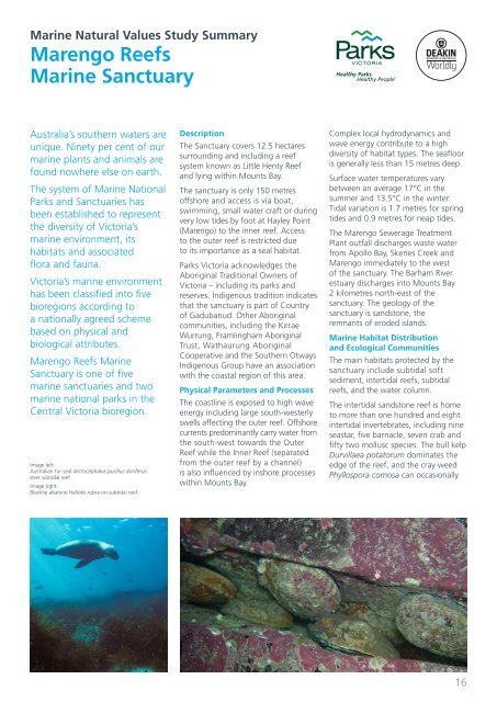
<strong>Marine</strong> <strong>Natural</strong> <strong>Values</strong> <strong>Study</strong> <strong>Summary</strong>Marengo Reefs<strong>Marine</strong> SanctuaryAustralia’s southern waters areunique. Ninety per cent of ourmarine plants and animals arefound nowhere else on earth.The system of <strong>Marine</strong> National<strong>Parks</strong> and Sanctuaries hasbeen established to representthe diversity of <strong>Victoria</strong>’smarine environment, itshabitats and associatedflora and fauna.<strong>Victoria</strong>’s marine environmenthas been classified into fivebioregions according toa nationally agreed schemebased on physical andbiological attributes.Marengo Reefs <strong>Marine</strong>Sanctuary is one of fivemarine sanctuaries and twomarine national parks in theCentral <strong>Victoria</strong> bioregion.Image left:Australian fur seal Arctocephalus pusillus doriferusover subtidal reef.Image right:Blacklip abalone Haliotis rubra on subtidal reef.DescriptionThe Sanctuary covers 12.5 hectaressurrounding and including a reefsystem known as Little Henty Reefand lying within Mounts Bay.The sanctuary is only 150 metresoffshore and access is via boat,swimming, small water craft or duringvery low tides by foot at Hayley Point(Marengo) to the inner reef. Accessto the outer reef is restricted dueto its importance as a seal habitat.<strong>Parks</strong> <strong>Victoria</strong> acknowledges theAboriginal Traditional Owners of<strong>Victoria</strong> – including its parks andreserves. Indigenous tradition indicatesthat the sanctuary is part of Countryof Gadubanud. Other Aboriginalcommunities, including the KirraeWurrung, Framlingham AboriginalTrust, Wathaurung AboriginalCooperative and the Southern OtwaysIndigenous Group have an associationwith the coastal region of this area.Physical Parameters and ProcessesThe coastline is exposed to high waveenergy including large south-westerlyswells affecting the outer reef. Offshorecurrents predominantly carry water fromthe south-west towards the OuterReef while the Inner Reef (separatedfrom the outer reef by a channel)is also influenced by inshore processeswithin Mounts Bay.Complex local hydrodynamics andwave energy contribute to a highdiversity of habitat types. The seaflooris generally less than 15 metres deep.Surface water temperatures varybetween an average 17°C in thesummer and 13.5°C in the winter.Tidal variation is 1.7 metres for springtides and 0.9 metres for neap tides.The Marengo Sewerage TreatmentPlant outfall discharges waste waterfrom Apollo Bay, Skenes Creek andMarengo immediately to the westof the sanctuary. The Barham Riverestuary discharges into Mounts Bay2 kilometres north-east of thesanctuary. The geology of thesanctuary is sandstone, theremnants of eroded islands.<strong>Marine</strong> Habitat Distributionand Ecological CommunitiesThe main habitats protected by thesanctuary include subtidal softsediment, intertidal reefs, subtidalreefs, and the water column.The intertidal sandstone reef is hometo more than one hundred and eightintertidal invertebrates, including nineseastar, five barnacle, seven crab andfifty two mollusc species. The bull kelpDurvillaea potatorum dominates theedge of the reef, and the cray weedPhyllospora comosa can occasionally16


