

Marine Natural Values Study Summary - Parks Victoria
Marine Natural Values Study Summary - Parks Victoria
Marine Natural Values Study Summary - Parks Victoria

You also want an ePaper? Increase the reach of your titles
YUMPU automatically turns print PDFs into web optimized ePapers that Google loves.
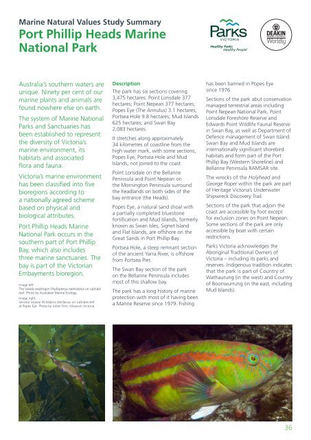
<strong>Marine</strong> <strong>Natural</strong> <strong>Values</strong> <strong>Study</strong> <strong>Summary</strong>Port Phillip Heads <strong>Marine</strong>National ParkAustralia’s southern waters areunique. Ninety per cent of ourmarine plants and animals arefound nowhere else on earth.The system of <strong>Marine</strong> National<strong>Parks</strong> and Sanctuaries hasbeen established to representthe diversity of <strong>Victoria</strong>’smarine environment, itshabitats and associatedflora and fauna.<strong>Victoria</strong>’s marine environmenthas been classified into fivebioregions according toa nationally agreed schemebased on physical andbiological attributes.Port Phillip Heads <strong>Marine</strong>National Park occurs in thesouthern part of Port PhillipBay, which also includesthree marine sanctuaries. Thebay is part of the <strong>Victoria</strong>nEmbayments bioregion.Image left:The weedy seadragon Phyllopteryx taeniolatus on subtidalreef. Photo by Australian <strong>Marine</strong> Ecology.Image right:Senator wrasse Pictilabrus laticlavius on subtidal reefat Popes Eye. Photo by Julian Finn, Museum <strong>Victoria</strong>DescriptionThe park has six sections covering3,475 hectares: Point Lonsdale 377hectares; Point Nepean 377 hectares;Popes Eye (The Annulus) 3.1 hectares;Portsea Hole 9.8 hectares; Mud Islands625 hectares; and Swan Bay2,083 hectares.It stretches along approximately34 kilometres of coastline from thehigh water mark, with some sections,Popes Eye, Portsea Hole and MudIslands, not joined to the coast.Point Lonsdale on the BellarinePeninsula and Point Nepean onthe Mornington Peninsula surroundthe headlands on both sides of thebay entrance (the Heads).Popes Eye, a natural sand shoal witha partially completed bluestonefortification and Mud Islands, formerlyknown as Swan Isles, Signet Islandand Flat Islands, are offshore on theGreat Sands in Port Phillip Bay.Portsea Hole, a steep remnant sectionof the ancient Yarra River, is offshorefrom Portsea Pier.The Swan Bay section of the parkon the Bellarine Peninsula includesmost of this shallow bay.The park has a long history of marineprotection with most of it having beena <strong>Marine</strong> Reserve since 1979. Fishinghas been banned in Popes Eyesince 1976.Sections of the park abut conservationmanaged terrestrial areas includingPoint Nepean National Park, PointLonsdale Foreshore Reserve andEdwards Point Wildlife Faunal Reservein Swan Bay, as well as Department ofDefence management of Swan Island.Swan Bay and Mud Islands areinternationally significant shorebirdhabitats and form part of the PortPhillip Bay (Western Shoreline) andBellarine Peninsula RAMSAR site.The wrecks of the Holyhead andGeorge Roper within the park are partof Heritage <strong>Victoria</strong>’s UnderwaterShipwreck Discovery Trail.Sections of the park that adjoin thecoast are accessible by foot exceptfor exclusion zones on Point Nepean.Some sections of the park are onlyaccessible by boat with certainrestrictions.<strong>Parks</strong> <strong>Victoria</strong> acknowledges theAboriginal Traditional Owners of<strong>Victoria</strong> – including its parks andreserves. Indigenous tradition indicatesthat the park is part of Country ofWathaurung (in the west) and Countryof Boonwurrung (in the east, includingMud Islands).36


