Water Rails & Oil - Historic Mid & South Jefferson County
An illustrated history of the Mid and South Jefferson County area, paired with the histories of companies, families and organizations that make the region great.
An illustrated history of the Mid and South Jefferson County area, paired with the histories of companies, families and organizations that make the region great.

You also want an ePaper? Increase the reach of your titles
YUMPU automatically turns print PDFs into web optimized ePapers that Google loves.
EPILOGUE<br />
S EPTEMBER 2005<br />
Long before the weather service gave them names, tropical storms, especially mighty hurricanes,<br />
rearranged the southeast Texas coast dramatically. Arthur Stilwell determined to build an outlet to<br />
the world from America’s midwest, via his Kansas City, Pittsburgh and Gulf Railroad, but he decided<br />
against developing his port directly on the Gulf, electing instead to locate shipping facilities on an<br />
inland lake and connect it to the sea by canal. So Port Arthur was founded, and from it came<br />
Nederland, Port Neches, Groves, and other communities in the southern portion of <strong>Jefferson</strong> <strong>County</strong>.<br />
Hurricanes are accepted by residents of Gulf coastal counties as the price of living where the nearby<br />
ocean supplies jobs and recreational opportunities as well as hurricanes; they take the good with the bad,<br />
and endured even such mighty blows as Hurricane Audrey in 1957. By 2000, most Gulf Coast residents<br />
had learned to store survival supplies—food, water, batteries, etc.—plywood cut to door and window<br />
measurements, and to have an evacuation plan awaiting the inevitable need for implementation.<br />
Late in August 2005, Hurricane Katrina flooded New Orleans, virtually destroying the Gulf Coast’s<br />
legendary playground, and sending hundreds of thousands of south Louisianans scurrying hundreds<br />
of miles inland seeking shelter. Residents all around the Gulf of Mexico were on edge; by late<br />
September, the season already had spawned seventeen named tropical storms, 10 had become<br />
hurricanes of 75 miles per hour or greater, two already had achieved Category 5, the most intense<br />
designation on the Saffir-Simpson Hurricane Scale.<br />
In September, three weeks after Katrina came ashore in eastern Louisiana, convection low-level<br />
circulation around an upper-level low developed in the Atlantic Ocean east of Cuba. The surface low<br />
caused a gradual acceleration of circular winds until September 20, when the disturbance—now and<br />
forever remembered as Rita—reached hurricane status. Rita passed over southern-most Florida into<br />
❖<br />
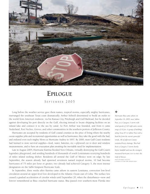
Hurricane Rita came ashore on<br />
September 24, 2005, near Sabine<br />
Pass, as a Category 3 storm with<br />
wind speeds of 120 mph and a storm<br />
surge of 10 feet. A group of buildings<br />
along Texas 87 in Sabine Pass took a<br />
hard hit from the storm’s powerful<br />
winds, All of <strong>Jefferson</strong> <strong>County</strong><br />
sustained heavy damage. Rita had<br />
been a Category 5 storm shortly<br />
before landfall and was the strongest<br />
measured hurricane ever to enter the<br />
Gulf of Mexico.<br />
PHOTO BY BRIAN VINCENT,<br />
COURTESY OF THE PORT ARTHUR NEWS.<br />
Epilogue ✦ 51