Water Rails & Oil - Historic Mid & South Jefferson County
An illustrated history of the Mid and South Jefferson County area, paired with the histories of companies, families and organizations that make the region great.
An illustrated history of the Mid and South Jefferson County area, paired with the histories of companies, families and organizations that make the region great.

You also want an ePaper? Increase the reach of your titles
YUMPU automatically turns print PDFs into web optimized ePapers that Google loves.
usinessmen throughout the country, urging<br />
them to take advantage of opportunities in the<br />
new city.<br />
Newspaper advertisements enticed the<br />
excursion parties to come to Port Arthur from the<br />
<strong>Mid</strong>west. They came by the hundreds in response<br />
to a glowing promise: “A healthy climate, good<br />
schools and churches, good farming lands and<br />
good markets in which to sell products of the soil<br />
are just a few inducements Port Arthur and<br />
<strong>Jefferson</strong> <strong>County</strong> offer to home seekers.”<br />
While the KCS rail line did not open up vast<br />
reaches of new territory in the west, it did serve<br />
to develop the U.S. frontier by establishing<br />
numerous new towns along the tracks<br />
connecting Kansas City to the Gulf of Mexico.<br />
KCS acquired more than forty thousand acres<br />
on the northern shore of Sabine Lake and the<br />
town of Port Arthur was laid out. For paying as<br />
much as seven dollars an acre, people laughed at<br />
him, local historians say, because the land was<br />
nothing but marshes, alligators and hordes of<br />
swarming mosquitoes.<br />
The town of Nederland was also founded<br />
as a mark of gratitude to Dutch investors.<br />
The <strong>Mid</strong>-<strong>County</strong> city’s name is the German<br />
and Dutch spelling and pronunciation for<br />
netherland, the descriptive name meaning<br />
“low land” for Holland and the five other<br />
provinces that together form the Republic of<br />
The Netherlands.<br />
Stilwell used four thousand acres for the original<br />
plat of the city, which extended from Houston<br />
Avenue east to what is now Woodworth Boulevard<br />
and from Lakeshore Drive north to Nineteenth<br />
Street. The last spike of Stilwell’s railroad was<br />
driven with great celebration on September 11,<br />
1897. The new city was a mere nine miles from<br />
deep saltwater and oceangoing vessels.<br />
Robert Gillham, Stilwell’s chief engineer,<br />
platted the new town’s streets and other<br />
improvements. He also was involved in digging<br />
of the Port Arthur Ship Canal, which connected<br />
❖<br />
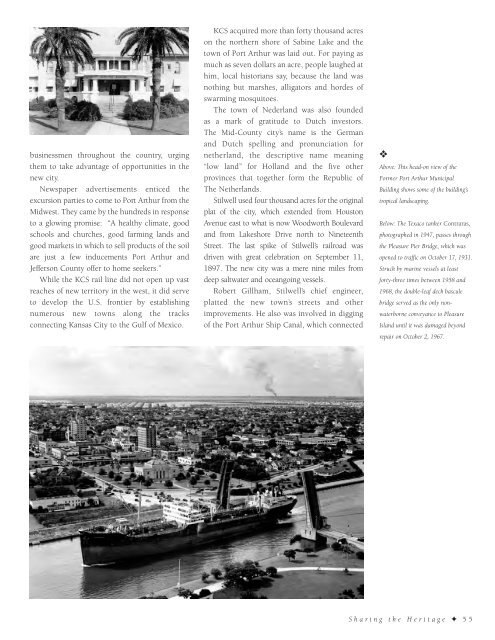
Above: This head-on view of the<br />
Former Port Arthur Municipal<br />
Building shows some of the building’s<br />
tropical landscaping.<br />
Below: The Texaco tanker Contraras,<br />
photographed in 1947, passes through<br />
the Pleasure Pier Bridge, which was<br />
opened to traffic on October 17, 1931.<br />
Struck by marine vessels at least<br />
forty-three times between 1958 and<br />
1968, the double-leaf deck bascule<br />
bridge served as the only nonwaterborne<br />
conveyance to Pleasure<br />
Island until it was damaged beyond<br />
repair on October 2, 1967.<br />
Sharing the Heritage ✦ 55