Goose Creek Watershed Management Plan Version - Charlotte ...
Goose Creek Watershed Management Plan Version - Charlotte ...
Goose Creek Watershed Management Plan Version - Charlotte ...

Create successful ePaper yourself
Turn your PDF publications into a flip-book with our unique Google optimized e-Paper software.
<strong>Goose</strong> <strong>Creek</strong> <strong>Watershed</strong> <strong>Management</strong> <strong>Plan</strong> <strong>Version</strong> 1...………………...October 31, 2009<br />
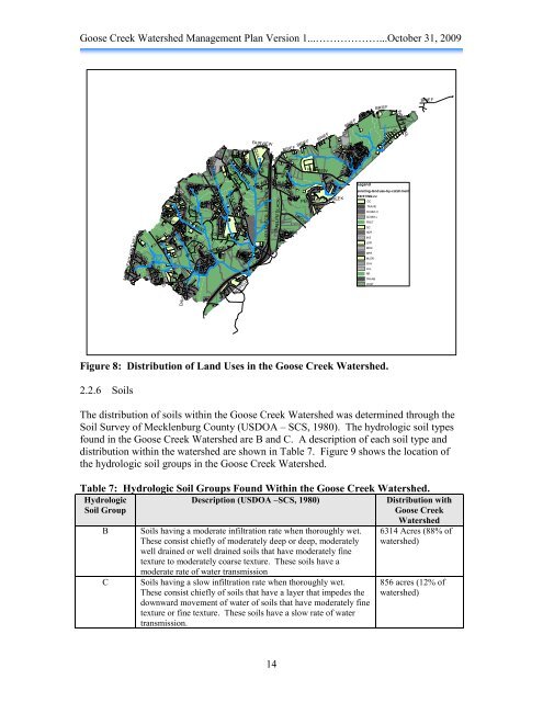
Figure 8: Distribution of Land Uses in the <strong>Goose</strong> <strong>Creek</strong> <strong>Watershed</strong>.<br />
2.2.6 Soils<br />
The distribution of soils within the <strong>Goose</strong> <strong>Creek</strong> <strong>Watershed</strong> was determined through the<br />
Soil Survey of Mecklenburg County (USDOA – SCS, 1980). The hydrologic soil types<br />
found in the <strong>Goose</strong> <strong>Creek</strong> <strong>Watershed</strong> are B and C. A description of each soil type and<br />
distribution within the watershed are shown in Table 7. Figure 9 shows the location of<br />
the hydrologic soil groups in the <strong>Goose</strong> <strong>Creek</strong> <strong>Watershed</strong>.<br />
Table 7: Hydrologic Soil Groups Found Within the <strong>Goose</strong> <strong>Creek</strong> <strong>Watershed</strong>.<br />
Hydrologic<br />
Soil Group<br />
MATTHEWS-MINT HILL<br />
DAVID<br />
FOUR OAKS<br />
WELL<br />
IDLEFIELD<br />
MINTWOOD<br />
HOODRIDGE<br />
PEGGY<br />
PIAFFE<br />
BEECH MINT<br />
DAVIS TRACE<br />
BLACKJACK<br />
CRESTHILL<br />
LAWYERS<br />
THOMPSON<br />
YARMOUTH<br />
BAIN SCHOOL<br />
JOLI CHEVAL<br />
MCWHIRTER<br />
FOX HOLLOW<br />
Description (USDOA –SCS, 1980) Distribution with<br />
<strong>Goose</strong> <strong>Creek</strong><br />
B Soils having a moderate infiltration rate when thoroughly wet.<br />
These consist chiefly of moderately deep or deep, moderately<br />
well drained or well drained soils that have moderately fine<br />
texture to moderately coarse texture. These soils have a<br />
JUMPER<br />
moderate rate of water transmission<br />
C Soils having a slow infiltration rate when thoroughly wet.<br />
These consist chiefly of soils that have a layer that impedes the<br />
downward movement of water of soils that have moderately fine<br />
texture or fine texture. These soils have a slow rate of water<br />
transmission.<br />
RANBURNE<br />
KIDWELLY<br />
FAIRVIEW<br />
QUAIL PARK<br />
SILAS ED<br />
I-485<br />
I-485<br />
I-485 INNER<br />
I-485 OUTER<br />
I-485<br />
ALLEN BLACK<br />
14<br />
BRIEF<br />
WHITMIRE<br />
ALEXIS<br />
LONG<br />
FIELDLARK<br />
BRIEF<br />
UNION<br />
BRIEF<br />
FAIRVIEW<br />
PERSIMMON CREEK<br />
BRIEF<br />
HANGING MOSS<br />
BRIEF<br />
QUARTERS<br />
Legend<br />
BRIEF<br />
TARA OAKS<br />
INDIAN TRAIL<br />
existing-landuse-by-catchment<br />
EXISTING LU<br />
GC<br />
TRANS<br />
COMM-H<br />
COMM-L<br />
FRST<br />
GC<br />
HDR<br />
INS<br />
LDR<br />
MDR<br />
MFR<br />
MLDR<br />
OI-H<br />
OI-L<br />
RR<br />
TRANS<br />
VCNT<br />
BRIEF<br />
<strong>Watershed</strong><br />
6314 Acres (88% of<br />
watershed)<br />
856 acres (12% of<br />
watershed)