Goose Creek Watershed Management Plan Version - Charlotte ...
Goose Creek Watershed Management Plan Version - Charlotte ...
Goose Creek Watershed Management Plan Version - Charlotte ...

Create successful ePaper yourself
Turn your PDF publications into a flip-book with our unique Google optimized e-Paper software.
<strong>Goose</strong> <strong>Creek</strong> <strong>Watershed</strong> <strong>Management</strong> <strong>Plan</strong> <strong>Version</strong> 1...………………...October 31, 2009<br />
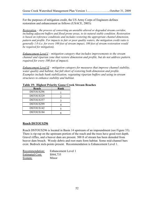
For the purposes of mitigation credit, the US Army Corps of Engineers defines<br />
restoration and enhancement as follows (USACE, 2003):<br />
Restoration – the process of converting an unstable altered or degraded stream corridor,<br />
including adjacent buffers and flood prone areas, to its natural stable condition. Restoration<br />
is based on reference conditions and includes restoring the appropriate channel dimension,<br />
pattern and profile. For impacts to fair or poor quality waters, the mitigation credit ratio is<br />
generally 1.0 (i.e. for every 100 feet of stream impact, 100 feet of stream restoration would<br />
be required for mitigation).<br />
Enhancement Level I – mitigation category that includes improvements to the stream<br />
channel and riparian zone that restore dimension and profile, but do not address pattern.<br />
required for every 100 feet of impact).<br />
Enhancement Level II – mitigation category for measures that improve channel stability,<br />
water quality and habitat, but fall short of restoring both dimension and profile.<br />
Examples include bank stabilization, vegetating riparian buffers and using in-stream<br />
structures to enhance stability and habitat.<br />
Table 19: Highest Priority <strong>Goose</strong> <strong>Creek</strong> Stream Reaches<br />
Reach Rank<br />
DSTOUS296 1<br />
DSTOUS329 2<br />
DSTOUS357 3<br />
DSTOUS299 4<br />
DSTOUS142 5<br />
DSTOUS184 6<br />
Reach DSTOUS296<br />
Reach DSTOUS296 is located in Basin 14 upstream of an impoundment (see Figure 33).<br />
There is rip-rap on the upstream portion of the reach and the trees have good root depth.<br />
Gravel riffles, and a beaver dam are present. 300 ft of stream has been denuded from<br />
beaver dam breach. Woody debris and root mats form habitat. Some mid-channel bars<br />
exist. Bedrock nick-points present. Recommendation is Enhancement Level 1.<br />
Recommendation: Enhancement Level 1<br />
Estimated Cost: $844,735<br />
System: Minor<br />
52