Goose Creek Watershed Management Plan Version - Charlotte ...
Goose Creek Watershed Management Plan Version - Charlotte ...
Goose Creek Watershed Management Plan Version - Charlotte ...
You also want an ePaper? Increase the reach of your titles
YUMPU automatically turns print PDFs into web optimized ePapers that Google loves.
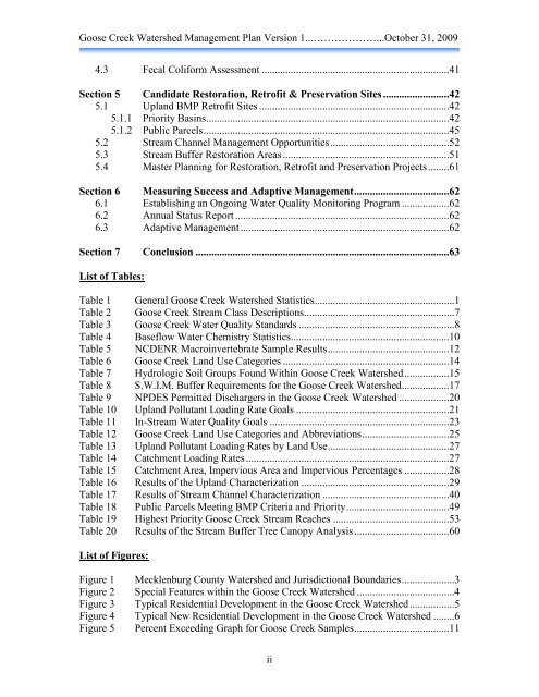
<strong>Goose</strong> <strong>Creek</strong> <strong>Watershed</strong> <strong>Management</strong> <strong>Plan</strong> <strong>Version</strong> 1...………………...October 31, 2009<br />
4.3 Fecal Coliform Assessment .......................................................................41<br />
Section 5 Candidate Restoration, Retrofit & Preservation Sites .........................42<br />
5.1 Upland BMP Retrofit Sites ........................................................................42<br />
5.1.1 Priority Basins ............................................................................................42<br />
5.1.2 Public Parcels .............................................................................................45<br />
5.2 Stream Channel <strong>Management</strong> Opportunities .............................................52<br />
5.3 Stream Buffer Restoration Areas ...............................................................51<br />
5.4 Master <strong>Plan</strong>ning for Restoration, Retrofit and Preservation Projects ........61<br />
Section 6 Measuring Success and Adaptive <strong>Management</strong> ....................................62<br />
6.1 Establishing an Ongoing Water Quality Monitoring Program ..................62<br />
6.2 Annual Status Report .................................................................................62<br />
6.3 Adaptive <strong>Management</strong> ...............................................................................62<br />
Section 7 Conclusion ................................................................................................63<br />
List of Tables:<br />
Table 1 General <strong>Goose</strong> <strong>Creek</strong> <strong>Watershed</strong> Statistics .....................................................1<br />
Table 2 <strong>Goose</strong> <strong>Creek</strong> Stream Class Descriptions .........................................................7<br />
Table 3 <strong>Goose</strong> <strong>Creek</strong> Water Quality Standards ...........................................................8<br />
Table 4 Baseflow Water Chemistry Statistics ............................................................10<br />
Table 5 NCDENR Macroinvertebrate Sample Results ..............................................12<br />
Table 6 <strong>Goose</strong> <strong>Creek</strong> Land Use Categories ...............................................................14<br />
Table 7 Hydrologic Soil Groups Found Within <strong>Goose</strong> <strong>Creek</strong> <strong>Watershed</strong> .................15<br />
Table 8 S.W.I.M. Buffer Requirements for the <strong>Goose</strong> <strong>Creek</strong> <strong>Watershed</strong>..................17<br />
Table 9 NPDES Permitted Dischargers in the <strong>Goose</strong> <strong>Creek</strong> <strong>Watershed</strong> ...................20<br />
Table 10 Upland Pollutant Loading Rate Goals ..........................................................21<br />
Table 11 In-Stream Water Quality Goals ....................................................................23<br />
Table 12 <strong>Goose</strong> <strong>Creek</strong> Land Use Categories and Abbreviations .................................25<br />
Table 13 Upland Pollutant Loading Rates by Land Use ..............................................27<br />
Table 14 Catchment Loading Rates .............................................................................27<br />
Table 15 Catchment Area, Impervious Area and Impervious Percentages .................28<br />
Table 16 Results of the Upland Characterization ........................................................29<br />
Table 17 Results of Stream Channel Characterization ................................................40<br />
Table 18 Public Parcels Meeting BMP Criteria and Priority .......................................49<br />
Table 19 Highest Priority <strong>Goose</strong> <strong>Creek</strong> Stream Reaches ............................................53<br />
Table 20 Results of the Stream Buffer Tree Canopy Analysis ....................................60<br />
List of Figures:<br />
Figure 1 Mecklenburg County <strong>Watershed</strong> and Jurisdictional Boundaries ....................3<br />
Figure 2 Special Features within the <strong>Goose</strong> <strong>Creek</strong> <strong>Watershed</strong> .....................................4<br />
Figure 3 Typical Residential Development in the <strong>Goose</strong> <strong>Creek</strong> <strong>Watershed</strong> .................5<br />
Figure 4 Typical New Residential Development in the <strong>Goose</strong> <strong>Creek</strong> <strong>Watershed</strong> ........6<br />
Figure 5 Percent Exceeding Graph for <strong>Goose</strong> <strong>Creek</strong> Samples ....................................11<br />
ii


