Goose Creek Watershed Management Plan Version - Charlotte ...
Goose Creek Watershed Management Plan Version - Charlotte ...
Goose Creek Watershed Management Plan Version - Charlotte ...

Create successful ePaper yourself
Turn your PDF publications into a flip-book with our unique Google optimized e-Paper software.
<strong>Goose</strong> <strong>Creek</strong> <strong>Watershed</strong> <strong>Management</strong> <strong>Plan</strong> <strong>Version</strong> 1...………………...October 31, 2009<br />
DSTOUS179<br />
DSTOUS127<br />
DSTOUS132<br />
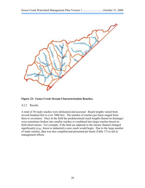
Figure 22: <strong>Goose</strong> <strong>Creek</strong> Stream Characterization Reaches.<br />
4.2.2 Results<br />
DSTOUS129<br />
DSTOUS211<br />
DSTOUS130<br />
DSTOUS134<br />
DSTOUS294<br />
DSTOUS210<br />
DSTOUS184<br />
USTODS135<br />
DSTOUS296<br />
DSTOUS213<br />
DSTOUS326<br />
DSTOUS142<br />
DSTOUS328<br />
DSTOUS215<br />
DSTOUS186<br />
DSTOUS357<br />
DSTOUS358<br />
DSTOUS187<br />
DSTOUS299<br />
DSTOUS297<br />
DSTOUS214<br />
A total of 30 study reaches were delineated and assessed. Reach lengths varied from<br />
several hundred feet to over 7000 feet. The number of reaches per basin ranged from<br />
three to seventeen. Once in the field the predetermined reach lengths (based on drainage)<br />
were sometimes broken into smaller reaches or combined into larger reaches based on<br />
field observations. For example, if the land use adjacent to the stream channel changed<br />
significantly (e.g., forest to industrial) a new reach would begin. Due to the large number<br />
of study reaches, data was also compiled and presented per basin (Table 17) to aid in<br />
management efforts.<br />
38<br />
DSTOUS329<br />
DSTOUS261<br />
USTODS394<br />
USTODS331<br />
USTODS333<br />
DSTOUS436