Goose Creek Watershed Management Plan Version - Charlotte ...
Goose Creek Watershed Management Plan Version - Charlotte ...
Goose Creek Watershed Management Plan Version - Charlotte ...
Create successful ePaper yourself
Turn your PDF publications into a flip-book with our unique Google optimized e-Paper software.
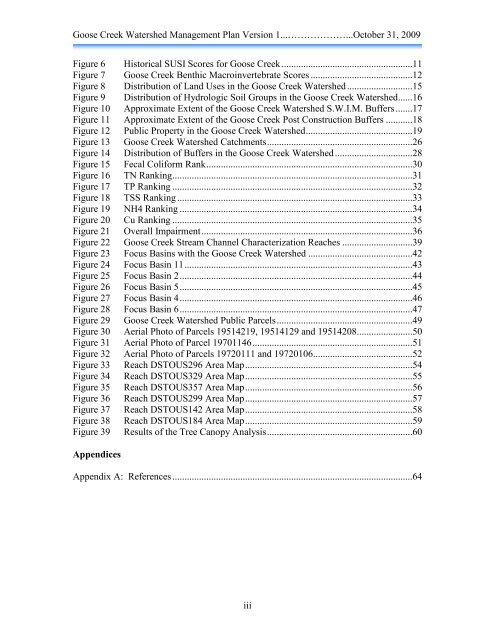
<strong>Goose</strong> <strong>Creek</strong> <strong>Watershed</strong> <strong>Management</strong> <strong>Plan</strong> <strong>Version</strong> 1...………………...October 31, 2009<br />
Figure 6 Historical SUSI Scores for <strong>Goose</strong> <strong>Creek</strong> ......................................................11<br />
Figure 7 <strong>Goose</strong> <strong>Creek</strong> Benthic Macroinvertebrate Scores ..........................................12<br />
Figure 8 Distribution of Land Uses in the <strong>Goose</strong> <strong>Creek</strong> <strong>Watershed</strong> ...........................15<br />
Figure 9 Distribution of Hydrologic Soil Groups in the <strong>Goose</strong> <strong>Creek</strong> <strong>Watershed</strong>......16<br />
Figure 10 Approximate Extent of the <strong>Goose</strong> <strong>Creek</strong> <strong>Watershed</strong> S.W.I.M. Buffers .......17<br />
Figure 11 Approximate Extent of the <strong>Goose</strong> <strong>Creek</strong> Post Construction Buffers ...........18<br />
Figure 12 Public Property in the <strong>Goose</strong> <strong>Creek</strong> <strong>Watershed</strong> ............................................19<br />
Figure 13 <strong>Goose</strong> <strong>Creek</strong> <strong>Watershed</strong> Catchments ............................................................26<br />
Figure 14 Distribution of Buffers in the <strong>Goose</strong> <strong>Creek</strong> <strong>Watershed</strong> ................................28<br />
Figure 15 Fecal Coliform Rank .....................................................................................30<br />
Figure 16 TN Ranking ...................................................................................................31<br />
Figure 17 TP Ranking ...................................................................................................32<br />
Figure 18 TSS Ranking .................................................................................................33<br />
Figure 19 NH4 Ranking ................................................................................................34<br />
Figure 20 Cu Ranking ...................................................................................................35<br />
Figure 21 Overall Impairment .......................................................................................36<br />
Figure 22 <strong>Goose</strong> <strong>Creek</strong> Stream Channel Characterization Reaches .............................39<br />
Figure 23 Focus Basins with the <strong>Goose</strong> <strong>Creek</strong> <strong>Watershed</strong> ...........................................42<br />
Figure 24 Focus Basin 11 ..............................................................................................43<br />
Figure 25 Focus Basin 2 ................................................................................................44<br />
Figure 26 Focus Basin 5 ................................................................................................45<br />
Figure 27 Focus Basin 4 ................................................................................................46<br />
Figure 28 Focus Basin 6 ................................................................................................47<br />
Figure 29 <strong>Goose</strong> <strong>Creek</strong> <strong>Watershed</strong> Public Parcels ........................................................49<br />
Figure 30 Aerial Photo of Parcels 19514219, 19514129 and 19514208 .......................50<br />
Figure 31 Aerial Photo of Parcel 19701146 ..................................................................51<br />
Figure 32 Aerial Photo of Parcels 19720111 and 19720106 .........................................52<br />
Figure 33 Reach DSTOUS296 Area Map .....................................................................54<br />
Figure 34 Reach DSTOUS329 Area Map .....................................................................55<br />
Figure 35 Reach DSTOUS357 Area Map .....................................................................56<br />
Figure 36 Reach DSTOUS299 Area Map .....................................................................57<br />
Figure 37 Reach DSTOUS142 Area Map .....................................................................58<br />
Figure 38 Reach DSTOUS184 Area Map .....................................................................59<br />
Figure 39 Results of the Tree Canopy Analysis ............................................................60<br />
Appendices<br />
Appendix A: References ...................................................................................................64<br />
iii


