Goose Creek Watershed Management Plan Version - Charlotte ...
Goose Creek Watershed Management Plan Version - Charlotte ...
Goose Creek Watershed Management Plan Version - Charlotte ...

Create successful ePaper yourself
Turn your PDF publications into a flip-book with our unique Google optimized e-Paper software.
<strong>Goose</strong> <strong>Creek</strong> <strong>Watershed</strong> <strong>Management</strong> <strong>Plan</strong> <strong>Version</strong> 1...………………...October 31, 2009<br />
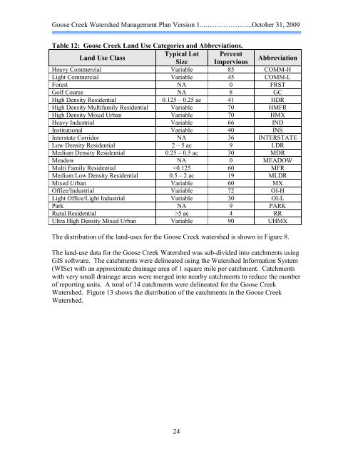
Table 12: <strong>Goose</strong> <strong>Creek</strong> Land Use Categories and Abbreviations.<br />
Land Use Class<br />
Typical Lot<br />
Size<br />
Percent<br />
Impervious Abbreviation<br />
Heavy Commercial Variable 85 COMM-H<br />
Light Commercial Variable 45 COMM-L<br />
Forest NA 0 FRST<br />
Golf Course NA 8 GC<br />
High Density Residential 0.125 – 0.25 ac 41 HDR<br />
High Density Multifamily Residential Variable 70 HMFR<br />
High Density Mixed Urban Variable 70 HMX<br />
Heavy Industrial Variable 66 IND<br />
Institutional Variable 40 INS<br />
Interstate Corridor NA 36 INTERSTATE<br />
Low Density Residential 2 – 5 ac 9 LDR<br />
Medium Density Residential 0.25 – 0.5 ac 30 MDR<br />
Meadow NA 0 MEADOW<br />
Multi Family Residential 5 ac 4 RR<br />
Ultra High Density Mixed Urban Variable 90 UHMX<br />
The distribution of the land-uses for the <strong>Goose</strong> <strong>Creek</strong> watershed is shown in Figure 8.<br />
The land-use data for the <strong>Goose</strong> <strong>Creek</strong> <strong>Watershed</strong> was sub-divided into catchments using<br />
GIS software. The catchments were delineated using the <strong>Watershed</strong> Information System<br />
(WISe) with an approximate drainage area of 1 square mile per catchment. Catchments<br />
with very small drainage areas were merged into nearby catchments to reduce the number<br />
of reporting units. A total of 14 catchments were delineated for the <strong>Goose</strong> <strong>Creek</strong><br />
<strong>Watershed</strong>. Figure 13 shows the distribution of the catchments in the <strong>Goose</strong> <strong>Creek</strong><br />
<strong>Watershed</strong>.<br />
24