Goose Creek Watershed Management Plan Version - Charlotte ...
Goose Creek Watershed Management Plan Version - Charlotte ...
Goose Creek Watershed Management Plan Version - Charlotte ...

Create successful ePaper yourself
Turn your PDF publications into a flip-book with our unique Google optimized e-Paper software.
<strong>Goose</strong> <strong>Creek</strong> <strong>Watershed</strong> <strong>Management</strong> <strong>Plan</strong> <strong>Version</strong> 1...………………...October 31, 2009<br />
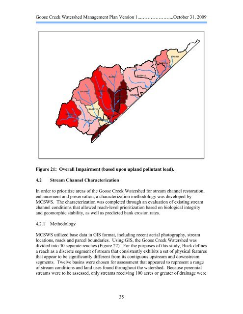
BASIN6<br />
Figure 21: Overall Impairment (based upon upland pollutant load).<br />
4.2 Stream Channel Characterization<br />
In order to prioritize areas of the <strong>Goose</strong> <strong>Creek</strong> <strong>Watershed</strong> for stream channel restoration,<br />
enhancement and preservation, a characterization methodology was developed by<br />
MCSWS. The characterization was completed through an evaluation of existing stream<br />
channel conditions that allowed reach-level prioritization based on biological integrity<br />
and geomorphic stability, as well as predicted bank erosion rates.<br />
4.2.1 Methodology<br />
BASIN8<br />
BASIN3<br />
BASIN10<br />
BASIN4<br />
BASIN13<br />
BASIN2<br />
BASIN1<br />
BASIN5<br />
BASIN11<br />
MCSWS utilized base data in GIS format, including recent aerial photography, stream<br />
locations, roads and parcel boundaries. Using GIS, the <strong>Goose</strong> <strong>Creek</strong> <strong>Watershed</strong> was<br />
divided into 30 separate reaches (Figure 22). For the purposes of this study, Buck defines<br />
a reach as a discrete segment of stream that consistently exhibits a set of physical features<br />
that appear to be significantly different from its contiguous upstream and downstream<br />
segments. Twelve basins were chosen for assessment that appeared to represent a range<br />
of stream conditions and land uses found throughout the watershed. Because perennial<br />
streams were to be assessed, only streams receiving 100 acres or greater of drainage were<br />
35<br />
BASIN9<br />
BASIN12<br />
BASIN14<br />
BASIN7