Stirring Up a Hornet's Nest: - UGA Laboratory of Archaeology ...
Stirring Up a Hornet's Nest: - UGA Laboratory of Archaeology ...
Stirring Up a Hornet's Nest: - UGA Laboratory of Archaeology ...

Create successful ePaper yourself
Turn your PDF publications into a flip-book with our unique Google optimized e-Paper software.
BBATTLEFIELD IMAGERY<br />
BV. The Battlefield<br />
Early Cartography<br />
No surviving Revolutionary War-era map <strong>of</strong> the Kettle Creek battlefield has been identified, despite<br />
extensive research by many historians over more than two centuries. That deficiency was noted by<br />
researcher Robert Scott Davis, Jr. and the present research confirms an absence <strong>of</strong> primary battle maps for<br />
Kettle Creek (Davis 1983:158).<br />
Two maps from the Colonial peri<strong>of</strong> show details relevant to the study area. A map <strong>of</strong> interior Georgia by<br />
Royal Surveyor William DeBrahm (1771) shows features in the upper coastal plain but DeBrahm’s map<br />
did not extend far enough northward to include Kettle Creek. In 1771, Kettle Creek was Indian land but it<br />
became Crown land after a major land cession was agreed upon in a 1773 treaty with the Creek and<br />
Cherokee Nations. A map showing the “Ceded Lands” was drafted by Royal Surveyor Philip Yonge<br />
(1773). While the project vicinity is included in Yonge’s map and major and minor stream drainages are<br />
shown, no cultural features are indicated in the Kettle Creek vicinity and Kettle Creek is not specifically<br />
identified by name.<br />
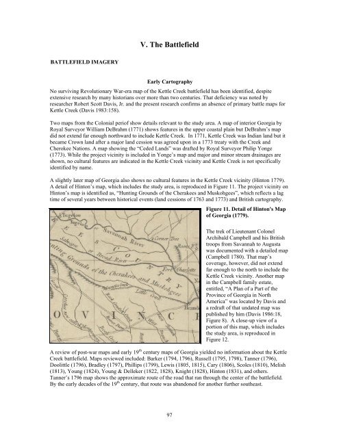
A slightly later map <strong>of</strong> Georgia also shows no cultural features in the Kettle Creek vicinity (Hinton 1779).<br />
A detail <strong>of</strong> Hinton’s map, which includes the study area, is reproduced in Figure 11. The project vicinity on<br />
Hinton’s map is identified as, “Hunting Grounds <strong>of</strong> the Cherakees and Muskohgees”, which reflects a lag<br />
time <strong>of</strong> several years between historical events (land cessions <strong>of</strong> 1763 and 1773) and British cartography.<br />
97<br />
Figure 11. Detail <strong>of</strong> Hinton's Map<br />
<strong>of</strong> Georgia (1779).<br />
The trek <strong>of</strong> Lieutenant Colonel<br />
Archibald Campbell and his British<br />
troops from Savannah to Augusta<br />
was documented with a detailed map<br />
(Campbell 1780). That map’s<br />
coverage, however, did not extend<br />
far enough to the north to include the<br />
Kettle Creek vicinity. Another map<br />
in the Campbell family estate,<br />
entitled, “A Plan <strong>of</strong> a Part <strong>of</strong> the<br />
Province <strong>of</strong> Georgia in North<br />
America” was located by Davis and<br />
a redraft <strong>of</strong> that undated map was<br />
published by him (Davis 1986:18,<br />
Figure 8). A close-up view <strong>of</strong> a<br />
portion <strong>of</strong> this map, which includes<br />
the study area, is reproduced in<br />
Figure 12.<br />
A review <strong>of</strong> post-war maps and early 19 th century maps <strong>of</strong> Georgia yielded no information about the Kettle<br />
Creek battlefield. Maps reviewed included: Barker (1794, 1796), Russell (1795, 1798), Tanner (1796),<br />
Doolittle (1796), Bradley (1797), Phillips (1799), Lewis (1805, 1815), Cary (1806), Scoles (1810), Melish<br />
(1813), Young (1824), Young & Delleker (1822, 1828), Knight (1828), Hinton (1831), and others.<br />
Tanner’s 1796 map shows the approximate route <strong>of</strong> the road that ran through the center <strong>of</strong> the battlefield.<br />
By the early decades <strong>of</strong> the 19 th century, that route was abandoned for another further southeast.