Stirring Up a Hornet's Nest: - UGA Laboratory of Archaeology ...
Stirring Up a Hornet's Nest: - UGA Laboratory of Archaeology ...
Stirring Up a Hornet's Nest: - UGA Laboratory of Archaeology ...

Create successful ePaper yourself
Turn your PDF publications into a flip-book with our unique Google optimized e-Paper software.
Locus A<br />
132<br />
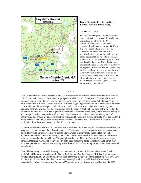
Figure 30. Kettle Creek, Loyalists<br />
Routed (Rauch in DAvis 2006).<br />
BACTIVITY LOCI<br />
Fourteen historic period activity loci and<br />
one prehistoric Locus were defined by the<br />
present survey <strong>of</strong> the Kettle Creek<br />
battlefield study area. These were<br />
designated by letters, A through O. These<br />
loci were areas where artifacts were<br />
concentrated. Some <strong>of</strong> them relate<br />
specifically to events in the battle, while<br />
others represent historic settlements. An<br />
area <strong>of</strong> Archaic period activity, which was<br />
unrelated to the Kettle Creek battle, was<br />
designated Locus O. The artifact inventory<br />
in Appendix I includes a column indicating<br />
the Locus where each artifact was located.<br />
A few stray artifacts were not given an<br />
activity locus designations. The locations<br />
<strong>of</strong> each historic activity locus (except<br />
Locus O) are shown in Figure 31. Each<br />
locus is described below.<br />
Locus A includes the knoll where the Kettle Creek Monument now stands, <strong>of</strong>ten referred to as Monument<br />
Hill. The obelisk monument is centered at grid point 9242N, 5194E. Other recent features <strong>of</strong> Locus A<br />
include a cement picnic table, historical markers, and a rectangular cemetery/cenotaph plot enclosure. The<br />
crest <strong>of</strong> the knoll at Locus A has been heavily disturbed by grading associated with the road and monument<br />
construction and the area is quite eroded. Exposed soil surfaces consisted <strong>of</strong> reddish sandy clay and<br />
saprolitic bedrock. Much <strong>of</strong> this soil erosion has been the result <strong>of</strong> foot and vehicular traffic by visitors to<br />
the battlefield over many decades. A gravel road leads to the summit <strong>of</strong> the knoll, which has also destroyed<br />
archeological evidence on portions <strong>of</strong> the knoll. In addition, some visitors to the site during the 20 th<br />
century used this area as a dumping ground for refuse, and tin cans and extraneous metal trash are scattered<br />
over portions <strong>of</strong> the knoll, which rendered metal detector use difficult to ineffective in those areas. No<br />
battle-related artifacts were located on the hill crest at Locus A.<br />
A concentrated search <strong>of</strong> Locus A yielded no battle evidence. The south slope <strong>of</strong> the monument hill is quite<br />
steep and it contains several large boulder outcrops. These outcrops, which contain several crevasses and<br />
niches that would have provided cover during a battle, were carefully metal detected for any battle<br />
evidence. Numerous metal cans, shotgun shells, and other modern metal trash were found in these areas<br />
but they contained no battle evidence. The precipitous slope on this side <strong>of</strong> the knoll is steep for horse<br />
travel and this area may have been avoided by both sides during the battle. Alternatively, riflemen may<br />
have been positioned in these areas but they either dropped no artifacts or any artifacts have been removed<br />
by collectors.<br />
Ground Penetrating Radar (GPR) survey was conducted on portions <strong>of</strong> this area <strong>of</strong> the Kettle Creek<br />
battlefield. GPR survey was directed by Daniel T. Elliott and Sheldon Skaggs. GPR data from three small<br />
rectangular, contiguous grids were collected. Each block was assigned a letter designation, A, B or C. GPR<br />
Blocks A and B were located within the cemetery/cenotaph enclosure. GPR Block C was located<br />
immediately north <strong>of</strong> this enclosure. Appendix IV contains a series <strong>of</strong> maps and pr<strong>of</strong>iles from the GPR