parte ii evaluacion y formulacion integral del territorio - Amagá
parte ii evaluacion y formulacion integral del territorio - Amagá
parte ii evaluacion y formulacion integral del territorio - Amagá

You also want an ePaper? Increase the reach of your titles
YUMPU automatically turns print PDFs into web optimized ePapers that Google loves.
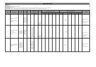
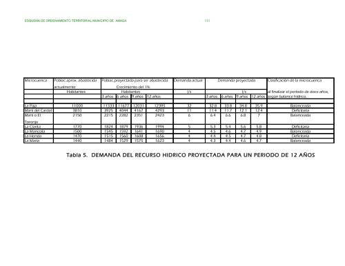
ESQUEMA DE ORDENAMIENTO TERRITORIAL MUNICIPIO DE AMAGA 111<br />
Microcuenca Poblac.aprox. abastecida<br />
Poblac.proyectada para ser abastecida<br />
Demanda actual Demanda proyectada Clasificación de la microcuenca<br />
actualmente<br />
Crecimiento <strong>del</strong> 1%<br />
Habitantes Habitantes l/s l/s al finalizar el período de doce años,<br />
3 años 6 años 9 años 12 años 3 años 6 años 9 años 12 años según balance hídrico.<br />
La Paja 11000 11333 11677 12031 12395 32 32.8 33.8 34.8 35.9 Balanceada<br />
Maní <strong>del</strong> Cardal 3810 3925 4044 4167 4293 11 11.4 11.7 12.1 12.4 Deficitaria<br />
Maní o El<br />
2150 2215 2282 2351 2423 6 6.4 6.6 6.8 7 Balanceada<br />
Toronjo<br />
La Clarita 1770 1824 1879 1936 1994 5 5.3 5.4 5.6 5.8 Deficitaria<br />
La Manizala 1500 1545 1592 1641 1690 4 4.5 4.6 4.7 4.9 Balanceada<br />
La Honda 1470 1515 1560 1608 1656 4 4.4 4.5 4.7 4.8 Deficitaria<br />
La María 1440 1484 1529 1575 1623 4 4.3 4.4 4.6 4.7 Balanceada<br />
Tabla 5. DEMANDA DEL RECURSO HIDRICO PROYECTADA PARA UN PERIODO DE 12 AÑOS
![Comisaria de Familia [Modo de compatibilidad] - Amagá](https://img.yumpu.com/18697114/1/190x135/comisaria-de-familia-modo-de-compatibilidad-amaga.jpg?quality=85)