Chapitre 2 : Description du projet - Rio Tinto Simandou
Chapitre 2 : Description du projet - Rio Tinto Simandou
Chapitre 2 : Description du projet - Rio Tinto Simandou

You also want an ePaper? Increase the reach of your titles
YUMPU automatically turns print PDFs into web optimized ePapers that Google loves.
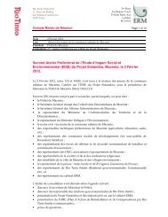
9°26'0"N<br />
13°24'0"W<br />
1045000<br />
13°24'0"W<br />
L égende:<br />
Sèrah<br />
Zone d'em prunt / Borrow Pit<br />
Infrastructures portuaires / P ort Infrastructure<br />
Chenal de dragage / D redging Channel<br />
Sourim a<br />
Tracé indicatif de la voie ferrée / Indicative Rail Alignm ent<br />
Agglomération / Settlement<br />
Chef lieu de préfecture / P refecture Chief Tow n<br />
Chef lieu de sous-préfecture / S ub-P refecture Chief Tow n<br />
Vilage / Vilage<br />
Ham eau / Ham let<br />
Route principale / P rim ary Road<br />
Route secondaire / S econdary Road<br />
Route tertiaire / Tertiary Route<br />
Sini<br />
M aligy a<br />
K aléa<br />
13°22'0"W<br />
13°22'0"W<br />
Senguelen<br />
680000<br />
680000<br />
Bam boukhoun<br />
Soungany ah<br />
Client: Taile: Titre:<br />
A4 Figure 2.17<br />
P rojection:W GS 1984 U TM Zone<br />
0 1<br />
kilom ètres<br />
13°20'0"W<br />
13°20'0"W<br />
Zones d'em prunt dans la zone <strong>du</strong> port /<br />
Borrow P its in the W ider Port Area<br />
D ate: 17/09/2012 Vérifié par: AM<br />
D essiné par: W B<br />
Guinea<br />
S ierra L eone<br />
Approuvé par: K R<br />
Projet: 0131299<br />
1045000<br />
9°26'0"N<br />
Echele: Com m e Barre d’échele<br />
File: 0131299Sim andouGIS_IG_CK \M aps\ERM \P ort\O ption_A\Project_D escription\po_A_Borrow_P its.m xd