Étude pédologique du comté de Huntingdon et Beauharnois - IRDA
Étude pédologique du comté de Huntingdon et Beauharnois - IRDA
Étude pédologique du comté de Huntingdon et Beauharnois - IRDA

Create successful ePaper yourself
Turn your PDF publications into a flip-book with our unique Google optimized e-Paper software.
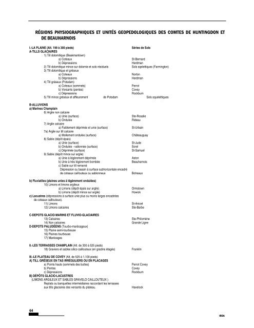
RÉGIONS PHYSIOGRAPHIQUES ET UNITÉS GEOPEDOLOGIQUES DES COMTES DE HUNTINGDON ET<br />
DE BEAUHARNOIS<br />
I.-LA PLAINE (Alt. 199 à 300 pieds) Séries <strong>de</strong> Sols<br />
A-TILLS GLACIAIRES<br />
1) Till dolomitique (Beakmantown)<br />
a) Coteaux St-Bernard<br />
b) Dépressions Herdman<br />
2) Till dolomitique mince sur dolomie <strong>et</strong> sols rési<strong>du</strong>els Sols sqel<strong>et</strong>tiques (Farmington)<br />
3) Till dolomitique <strong>et</strong> gréseux<br />
a) Coteaux Norton<br />
b) Dépressions Herdman<br />
4) Till gréseux (Potsdam)<br />
a) Coteaux (somm<strong>et</strong>s) Perrot<br />
b) Versants (pentes) Covey<br />
c) Dépressions Rockburn<br />
5) Till mince gréseux <strong>et</strong> affleurement <strong>de</strong> Potsdam Sols squel<strong>et</strong>tiques<br />
B-ALLUVIONS<br />
a) Marines Champlain<br />
6) Argile non calcaire<br />
a) Unie (surface) Ste-Rosalie<br />
b) On<strong>du</strong>lée Ri<strong>de</strong>au<br />
7) Argile calcaire<br />
a) Faiblement déprimée <strong>et</strong> unie (surface) St-Urbain<br />
7a) Argile sur till calcaire<br />
a) Mollement on<strong>du</strong>lée (surface) Châteauguay<br />
8) Sable (dépôt épais)<br />
a) Unie (surface) St-Ju<strong>de</strong><br />
b) On<strong>du</strong>lée - vallonnée (surface) Sorel<br />
c) Déprimée (surface) St-Samuel<br />
9) Sable (dépôt mince sur argile)<br />
a) Unie à légèrement déprimée Aston<br />
b) Unie à très légèrement bombée <strong>Beauharnois</strong><br />
c) Sable sur till remanié<br />
Dépression ou bassin à surface subhorizontale encadré<br />
<strong>de</strong> coteaux caillouteux ou sablonneux Botreaux<br />
b) Fluviatiles (plaines unies à légèrement on<strong>du</strong>lées)<br />
10) Limons <strong>et</strong> limons argileux<br />
a) Limons (dépôt épais sur argile) Ormstown<br />
b) Limons (dépôt mince sur argile) Howick<br />
c) Lacustres (dépressions à surface unie plus ou moins larges encadrées<br />
<strong>de</strong> coteaux caillouteux).<br />
11) Limons St-Anic<strong>et</strong><br />
12) Limons calcaires Ste-Barbe<br />
C-DEPOTS GLACIO-MARINS ET FLUVIO-GLACIAIRES<br />
13) Calcaires Ste-Philomène<br />
14) Non calcaires Gran<strong>de</strong> Ligne<br />
D-DEPOTS PALUDÉENS (Tourbo-marécageux)<br />
15) Plaine semi-tourbeuse<br />
16) Plaines tourbeuse<br />
17) Marécages<br />
II.-LES TERRASSES CHAMPLAIN (Alt. <strong>de</strong> 300 à 525 pieds)<br />
18) Graviers <strong>et</strong> sables silico caillouteux (en gradins étagés) Franklin<br />
III.-LE PLATEAU DE COVEY (Alt. <strong>de</strong> 525 à 1,100 pieds)<br />
A) TILL GRÉSEUX EN TAS IRRÉGULIERS OU EN PLACAGES<br />
a) Points hauts (somm<strong>et</strong>s <strong>de</strong>s buttes) Perrot Covey<br />
b) Pentes Covey<br />
c) Dépressions Rockburn<br />
B) DÉPÔTS GLACIO-LACUSTRES<br />
(LIMONS ARGILEUX ET SABLES GRAVELO CAILLOUTEUX )<br />
Replats ou banqu<strong>et</strong>tes intermédiaires raccordant les terrasses<br />
aux tills glaciaires <strong>de</strong>s versants <strong>du</strong> plateau. Havelock<br />
64<br />
Comté <strong>de</strong> <strong>Huntingdon</strong> <strong>et</strong> <strong>Beauharnois</strong> - <strong>IRDA</strong>