GEOmedia_2_2022
Rivista Italiana di geomatica
Rivista Italiana di geomatica

Create successful ePaper yourself
Turn your PDF publications into a flip-book with our unique Google optimized e-Paper software.
AEROFOTOTECA<br />
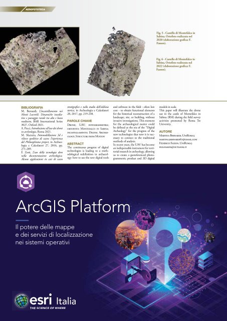
Fig. 5 - Castello di Montefalco in<br />
Sabina. Ortofoto realizzata nel<br />
2020 (elaborazione grafica: F.<br />
Fasson).<br />
Fig. 6 - Castello di Montefalco in<br />
Sabina. Ortofoto realizzata nel<br />
<strong>2022</strong> (elaborazione grafica: F.<br />
Fasson).<br />
BIBLIOGRAFIA<br />
M. Bernardi, L’incastellamento nei<br />
Monti Lucretili. Dinamiche insediative<br />
e paesaggio rurale tra alto e basso<br />
medioevo, BAR International Series<br />
3027, Oxford 2021.<br />
A. Pecci, Introduzione all’uso dei droni<br />
in archeologia, Roma 2021.<br />
M. Sfacteria, Fotomodellazione 3d e<br />
rilievo speditivo di scavo: l’esperienza<br />
del Philosophiana project, in Archeologia<br />
e Calcolatori 27, 2016, pp.<br />
271-289.<br />
F. Zoni, L’uso della tecnologia dem<br />
nella documentazione archeologica.<br />
Alcune applicazioni in casi di scavo<br />
stratigrafico e nello studio dell’edilizia<br />
storica, in Archeologia e Calcolatori<br />
28, 2017, pp. 219-238.<br />
PAROLE CHIAVE<br />
Drone; UAV; fotogrammetria;<br />
ortofoto; Montefalco in Sabina;<br />
incastellamento; Digital Archaeology;<br />
Structure from Motion<br />
ABSTRACT<br />
The continuous progress of digital<br />
technologies is leading to a methodological<br />
redefinition in archaeology:<br />
how to use the new digital tools<br />
and software in the field - often low<br />
cost - to obtain functional elements<br />
for the historical reconstruction of a<br />
landscape, site, or building, without<br />
invasive investigations. This moment<br />
for the archaeological matter could<br />
be defined as the era of the “Digital<br />
Archeology” for the progress of the<br />
new technologies that now it is necessary<br />
to connect to the traditional<br />
methods of analysis.<br />
In recent years, the UAV has become<br />
an indispensable instrument for territorial<br />
research in archeology, allowing<br />
us to create a georeferenced photogrammetric<br />
product and 3D digital<br />
models in scale.<br />
This paper will illustrate the drone<br />
use in the castle of Montefalco in<br />
Sabina (RM) during the field survey<br />
activities promoted by Roma Tre<br />
University.<br />
AUTORE<br />
Martina Bernardi, UniRoma3<br />
martina.bernardi87@gmail.com<br />
Federico Fasson, UniRoma3<br />
fed.fasson@outlook.it