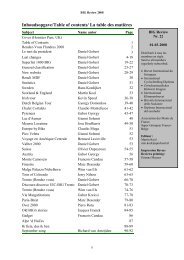
Inhoudsopgave/Table of contents/ La table des matières - Free
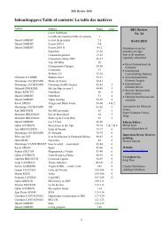
Inhoudsopgave/Table of contents/ La table des matières - Free
Inhoudsopgave/Table of contents/ La table des matières - Free

Create successful ePaper yourself
Turn your PDF publications into a flip-book with our unique Google optimized e-Paper software.
BIG Review 2009<br />
Austrian tours – in East- and South-Tirol<br />
György DOMONKOS<br />
In the end <strong>of</strong> 2007. some <strong>of</strong> my<br />
friends and I planned a few<br />
days Austrian cycling tour in<br />
2008. We decided to see a<br />
stage <strong>of</strong> the Giro d’Italia, so the<br />
date <strong>of</strong> the tour would be the<br />
end <strong>of</strong> May. Gábor Kreicsi, our<br />
tour organizer<br />
planned a program,<br />
that suited our<br />
requirements. On the<br />
26th <strong>of</strong> May was<br />
planned a stage <strong>of</strong> the<br />
Giro to the Kronplatz<br />
(Plan de Corones),<br />
that was a time trial<br />
stage to the hill. The<br />
way <strong>of</strong> the race went<br />
close to the Passo<br />
Furcia (BIG 709).<br />
On 23th <strong>of</strong> May we<br />
woke up early and we<br />
began our long way to<br />
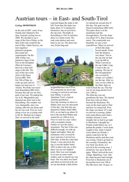
Austria. We broke our travel<br />
near Katschberg (BIG 643),<br />
because this top was our first<br />
goal <strong>of</strong> our tour. We parked the<br />
car in St. Margarethen and<br />
departed our short tour to the<br />
Katschberg. The weather was<br />
very changeable, once was<br />
raining, after the sun shone and<br />
the air was cool. First we went<br />
along a river on a cycling road<br />
to the St. Michael im Lungau.<br />
Here we arrived at the main<br />
road and began the slope to the<br />
hill. From here the slope was<br />
hard, about 15 % during few<br />
kilometres, but we arrived at<br />
the top soon. The hight <strong>of</strong><br />
Katschberg is 1641 m and here<br />
there is a winter resort. We<br />
took some photos and went<br />
back to our car. The short tour<br />
was 24 km long and<br />
heightdifference was 670 m.<br />
We continued our travel and<br />
evening we arrived at our base<br />
near Sillian, it was the<br />
Apartman Tyrol, a typical<br />
Austrian guesthouse.<br />
Next day morning we drove to<br />
Huben, here was our start point<br />
<strong>of</strong> this day. Our first trip was<br />
planned to Staller Sattel (BIG<br />
623), so we had to go about 36<br />
km to the top from Huben and<br />
waited for us 1200 m level.<br />
First we went in a nice valley<br />
with a mountain stream.<br />
Farther we saw the snowy<br />
mountains. The last 10 km was<br />
difficult enough, we rode up<br />
higher and higher. Here the<br />
mountains were covered by<br />
snow and once I arrived at a<br />
little lake, in that the water had<br />
frozen. I soon arrived at the<br />
top, it was the Staller Sattel<br />
2052 m above the sea, so this<br />
place was my new highest<br />
point. Here was cool enough,<br />
so we put on some warm<br />
clothes, and we started our way<br />
back. Our way back was faster<br />
and when we arrived at the car<br />
we ate and drank a little before<br />
96<br />
we started our second tour <strong>of</strong><br />
this day. Our goal was the<br />
Neues-Lucknerhaus (BIG 626).<br />
This place there is in the<br />
mountains near the<br />
Grossglockner. First the slope<br />
was about 10 %, than it became<br />
easier. The countryside was<br />
beautiful, we saw a nice<br />
waterfall too. When we arrived<br />
at Kals the slope<br />
becam harder. From<br />
here the distance<br />
was about 7 km to<br />
the top, but we had<br />
to go up 600 m.<br />
When I arrived at<br />
the top I didn’t stop,<br />
I went to the car<br />
parking. The top <strong>of</strong><br />
the Grossglockner<br />
was covered by<br />
clouds, so I couldn’t<br />
see the top. After we<br />
were at rest a little in<br />
the hütte, than we<br />
went to back the car. This trip<br />
was 41 km long and the level<br />
was 1200 m.<br />
The third day was our<br />
guesthouse the base. We started<br />
from here with our bikes<br />
forward the Hochstein. We<br />
went on the main road to Thal<br />
and here we turned left. First<br />
the slope was about 10 % and<br />
we arrived a crossing. Gábor<br />
took some photos and I had a<br />
mistake, because I went<br />
straight, but we had to go right<br />
to Hochstein. I thought my<br />
friends would follow me, so I<br />
pushed the pedals. I went alone<br />
roughly 6 km, when I started<br />
worry about my friends. I<br />
asked a man how far the<br />
Hochstein and he said this road<br />
was wrong. I had to go back to<br />
the crossing. Fortunately, the<br />
way back was down, so I<br />
arrived at the crossing soon. I<br />
started my way up to the hill<br />
again. When I arrived the next<br />
village, Bannberg, I saw, that<br />
the slope became hard enough.<br />
From her to Hochstein was 6<br />
km and the level was 700 m.<br />
My bike have only 18 gear, so