camp ripley and arden hills minnesota army national guard training ...
camp ripley and arden hills minnesota army national guard training ...
camp ripley and arden hills minnesota army national guard training ...

You also want an ePaper? Increase the reach of your titles
YUMPU automatically turns print PDFs into web optimized ePapers that Google loves.
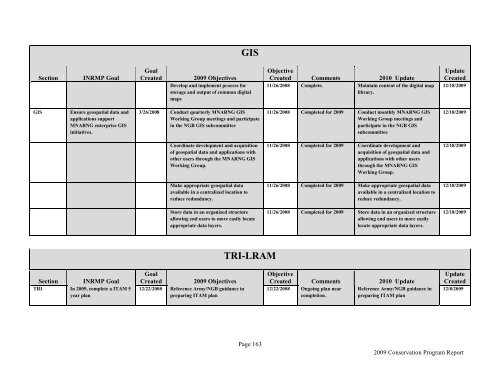
Section INRMP Goal<br />
GIS Ensure geospatial data <strong>and</strong><br />
applications support<br />
MNARNG enterprise GIS<br />
initiatives.<br />
Section INRMP Goal<br />
TRI In 2009, complete a ITAM 5<br />
year plan<br />
GIS<br />
Goal<br />
Created 2009 Objectives<br />
Develop <strong>and</strong> implement process for<br />
storage <strong>and</strong> output of common digital<br />
maps<br />
3/26/2008 Conduct quarterly MNARNG GIS<br />
Working Group meetings <strong>and</strong> participate<br />
in the NGB GIS subcommittee<br />
Coordinate development <strong>and</strong> acquisition<br />
of geospatial data <strong>and</strong> applications with<br />
other users through the MNARNG GIS<br />
Working Group.<br />
Make appropriate geospatial data<br />
available in a centralized location to<br />
reduce redundancy.<br />
Store data in an organized structure<br />
allowing end users to more easily locate<br />
appropriate data layers.<br />
Goal<br />
Created 2009 Objectives<br />
12/22/2008 Reference Army/NGB guidance in<br />
preparing ITAM plan<br />
TRI-LRAM<br />
Page 163<br />
Objective<br />
Created Comments 2010 Update<br />
11/26/2008 Complete. Maintain content of the digital map<br />
library.<br />
11/26/2008 Completed for 2009 Conduct monthly MNARNG GIS<br />
Working Group meetings <strong>and</strong><br />
participate in the NGB GIS<br />
subcommittee<br />
11/26/2008 Completed for 2009 Coordinate development <strong>and</strong><br />
acquisition of geospatial data <strong>and</strong><br />
applications with other users<br />
through the MNARNG GIS<br />
Working Group.<br />
11/26/2008 Completed for 2009 Make appropriate geospatial data<br />
available in a centralized location to<br />
reduce redundancy.<br />
11/26/2008 Completed for 2009 Store data in an organized structure<br />
allowing end users to more easily<br />
locate appropriate data layers.<br />
Objective<br />
Created Comments 2010 Update<br />
12/22/2008 Ongoing plan near Reference Army/NGB guidance in<br />
completion.<br />
preparing ITAM plan<br />
Update<br />
Created<br />
12/18/2009<br />
12/18/2009<br />
12/18/2009<br />
12/18/2009<br />
12/18/2009<br />
Update<br />
Created<br />
12/8/2009<br />
2009 Conservation Program Report