

Understanding Map Projections
Understanding Map Projections
Understanding Map Projections

You also want an ePaper? Increase the reach of your titles
YUMPU automatically turns print PDFs into web optimized ePapers that Google loves.
National Transformation version 2<br />
Like the United States, Canada uses a grid-based<br />
method to convert between NAD 1927 and NAD<br />
1983. The National Transformation version 2 (NTv2)<br />
method is quite similar to NADCON. A set of binary<br />
files contains the differences between the two<br />
geographic coordinate systems. A bilinear<br />
interpolation is used to calculate the exact values for<br />
a point.<br />
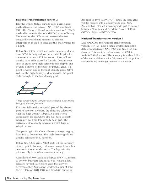
Unlike NADCON, which can only use one grid at a<br />
time, NTv2 is designed to check multiple grids for<br />
the most accurate shift information. A set of lowdensity<br />
base grids exists for Canada. Certain areas<br />
such as cities have high-density local subgrids that<br />
overlay portions of the base, or parent, grids. If a<br />
point is within one of the high-density grids, NTv2<br />
will use the high-density grid; otherwise, the point<br />
‘falls through’ to the low-density grid.<br />
Australia of 1994 (GDA 1994). Later, the state grids<br />
will be merged into a countrywide grid. New<br />
Zealand has released a countrywide grid to convert<br />
between New Zealand Geodetic Datum of 1949<br />
(NZGD 1949) and NZGD 2000.<br />
National Transformation version 1<br />
Like NADCON, the National Transformation<br />
version 1 (NTv1) uses a single grid to model the<br />
differences between NAD 1927 and NAD 1983 in<br />
Canada. This version is also known as CNT in<br />
ArcInfo Workstation. The accuracy is within 0.01 m<br />
of the actual difference for 74 percent of the points<br />
and within 0.5 m for 93 percent of the cases.<br />
A high-density subgrid with four cells overlaying a low-density<br />
base grid, also with four cells.<br />
If a point falls in the lower-left part of the above<br />
picture between the stars, the shifts are calculated<br />
with the high-density subgrid. A point whose<br />
coordinates are anywhere else will have its shifts<br />
calculated with the low-density base grid. The<br />
software automatically calculates which base or<br />
subgrid to use.<br />
The parent grids for Canada have spacings ranging<br />
from five to 20 minutes. The high-density grids are<br />
usually cell sizes of 30 seconds.<br />
Unlike NADCON grids, NTv2 grids list the accuracy<br />
of each point. Accuracy values can range from a few<br />
centimeters to around a meter. The high-density<br />
grids usually have subcentimeter accuracy.<br />
Australia and New Zealand adopted the NTv2 format<br />
to convert between datums as well. Australia has<br />
released several state-based grids that convert<br />
between either Australian Geodetic Datum of 1966<br />
(AGD 1966) or AGD 1984 and Geodetic Datum of<br />
28 • <strong>Understanding</strong> <strong>Map</strong> <strong>Projections</strong>


