

Understanding Map Projections
Understanding Map Projections
Understanding Map Projections

Create successful ePaper yourself
Turn your PDF publications into a flip-book with our unique Google optimized e-Paper software.
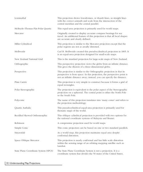
Loximuthal<br />
McBryde–Thomas Flat-Polar Quartic<br />
Mercator<br />
Miller Cylindrical<br />
Mollweide<br />
New Zealand National Grid<br />
Orthographic<br />
Perspective<br />
Plate Carrée<br />
Polar Stereographic<br />
Polyconic<br />
Quartic Authalic<br />
Rectified Skewed Orthomorphic<br />
Robinson<br />
Simple Conic<br />
Sinusoidal<br />
Space Oblique Mercator<br />
State Plane Coordinate System (SPCS)<br />
This projection shows loxodromes, or rhumb lines, as straight lines<br />
with the correct azimuth and scale from the intersection of the<br />
central meridian and the central parallel.<br />
This equal-area projection is primarily used for world maps.<br />
Originally created to display accurate compass bearings for sea<br />
travel. An additional feature of this projection is that all local shapes<br />
are accurate and clearly defined.<br />
This projection is similar to the Mercator projection except that the<br />
polar regions are not as areally distorted.<br />
Carl B. Mollweide created this pseudocylindrical projection in 1805. It<br />
is an equal-area projection designed for small-scale maps.<br />
This is the standard projection for large-scale maps of New Zealand.<br />
This perspective projection views the globe from an infinite distance.<br />
This gives the illusion of a three-dimensional globe.<br />
This projection is similar to the Orthographic projection in that its<br />
perspective is from space. In this projection, the perspective point is<br />
not an infinite distance away; instead, you can specify the distance.<br />
This projection is very simple to construct because it forms a grid of<br />
equal rectangles.<br />
The projection is equivalent to the polar aspect of the Stereographic<br />
projection on a spheroid. The central point is either the North Pole<br />
or the South Pole.<br />
The name of this projection translates into ‘many cones’ and refers to<br />
the projection methodology.<br />
This pseudocylindrical equal-area projection is primarily used for<br />
thematic maps of the world.<br />
This oblique cylindrical projection is provided with two options for<br />
the national coordinate systems of Malaysia and Brunei.<br />
A compromise projection used for world maps.<br />
This conic projection can be based on one or two standard parallels.<br />
As a world map, this projection maintains equal area despite<br />
conformal distortion.<br />
This projection is nearly conformal and has little scale distortion<br />
within the sensing range of an orbiting mapping satellite such as<br />
Landsat.<br />
The State Plane Coordinate System is not a projection. It is a<br />
coordinate system that divides the 50 states of the United States,<br />
32 •<strong>Understanding</strong> <strong>Map</strong> <strong>Projections</strong>


