Tampa Bay Region - Southwest Florida Water Management District
Tampa Bay Region - Southwest Florida Water Management District
Tampa Bay Region - Southwest Florida Water Management District
You also want an ePaper? Increase the reach of your titles
YUMPU automatically turns print PDFs into web optimized ePapers that Google loves.
N374<br />
Mapping - Pasco County - NAVD88 Vertical Control Densification<br />
Project Type<br />
AORs<br />
Flood Protection<br />
Cooperative Funding<br />
Strategic Initiatives<br />
Floodplain <strong>Management</strong><br />
Pasco County<br />
Cooperator(s)<br />
Project Manager Jim Owens<br />
Task Manager(s) Jim Owens<br />
Status<br />
Proposed Coop. Funding Application<br />
Recommendation<br />
Fund as a Low priority. This project supports the NAVD88 Migration Project (B134) and the topographic mapping and watershed<br />
modeling currently underway for Pasco County. This will be the third year of this survey control densification effort. The County has<br />
been an active partner with the <strong>District</strong> in establishing survey control since 1990 and continues to be a leader in this area.<br />
Description<br />
This project improves the quality and accuracy of the vertical control survey network in Pasco County by creating approximately 150<br />
new benchmarks. The <strong>District</strong> has been cooperating with the County, <strong>Florida</strong> Department of Environmental Protection and the<br />
National Geodetic Survey on the replacement of the obsolete National Geodetic Vertical Datum of 1929 (NGVD29) with the more<br />
accurate North American Vertical Datum of 1988 (NAVD88). This is the third year that the County and <strong>District</strong> have cooperated on<br />
this effort. This project enables public and private surveyors and engineers to make an orderly transition to NAVD88. It also allows<br />
the County to be on the same vertical datum as the <strong>District</strong> and to comply with the federal and state surveying and mapping<br />
requirements.<br />
Benefits<br />
This project has the following benefits. 1) Reduces costs to public and private surveyors by increasing the density and accuracy of<br />
the survey benchmarks. 2) Supports the development of <strong>Water</strong>shed <strong>Management</strong> Plans for the County thus contributing to flood<br />
protection, natural systems, water quality and water supply. 3) Pasco County is a participant in FEMA's Community Rating System<br />
and this project will help improve the community rating. This reduces the cost of federal flood insurance for policy-holders in the<br />
County. 4) Supports County and <strong>District</strong> topographic mapping efforts.<br />
Costs<br />
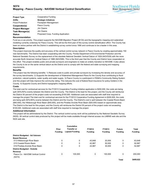
The total cost for contractual services for the FY2013 Cooperative Funding Initiative application is $200,000, the costs are being<br />
split (50%/50%) evenly between the <strong>District</strong> and the County. The <strong>District</strong> is the lead for this project, and the County will reimburse<br />
the <strong>District</strong> 50 percent of the project costs not exceeding $100,000. Additional costs are associated with staff time required to<br />
manage the project.The total cost for contractual services for the FY2012 Cooperative Funding Agreement is $200,000, the costs<br />
are being split (50%/50%) evenly between the <strong>District</strong> and the County. The <strong>District</strong>'s cost is split between the Coastal Rivers Basin<br />
($40,000), the Hillsborough River Basin ($40,000), and the Pinellas Anclote River Basin ($20,000) based on approximate area.<br />
The <strong>District</strong> is the lead for this project, and the County will reimburse the <strong>District</strong> 50 percent of the project costs not exceeding<br />
$100,000. Additional costs are associated with staff time required to manage the project.<br />
Additional Information<br />
This project will be administered by the <strong>District</strong>. The vertical control survey work will be published by the National Geodetic Survey<br />
(NGS). All vertical control data produced by this project will be made available through Internet access via LABINS web site and the<br />
NGS web site.<br />
Prior<br />
Funding<br />
Cumulative<br />
Transfer or<br />
Lapsed Funding<br />
FY2012<br />
Funding<br />
FY2013<br />
Funding<br />
Future<br />
Funding<br />
Total<br />
Funding<br />
<strong>District</strong> Budgeted - Ad Valorem<br />
Based Revenue<br />
013 Hillsborough River Basin 0 0 43,848 20,000<br />
0<br />
63,848<br />
015 Coastal Rivers Basin 0 0 42,887 50,000<br />
0<br />
92,887<br />
016 Pinellas-Anclote River Basin 0 0 22,887 30,000<br />
0<br />
52,887<br />
<strong>District</strong> Budgeted - Outside<br />
Revenue<br />
Pasco Co - NAVD88 Vertical Control<br />
(N374)<br />
0 100,000 0 100,000<br />
0 200,000<br />
Total<br />
$409,622<br />
97


