

Toolkits for Urban Transport Development - UNEP
Toolkits for Urban Transport Development - UNEP
Toolkits for Urban Transport Development - UNEP

Create successful ePaper yourself
Turn your PDF publications into a flip-book with our unique Google optimized e-Paper software.
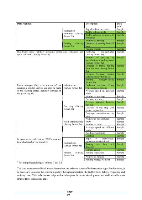
Data required Description Data<br />
level 1<br />
Intersection<br />
treatment (Survey<br />
<strong>for</strong>mat 2b)<br />
Parking<br />
<strong>for</strong>mat 2c)<br />
(Survey<br />
Para-transit (auto rickshaw including shared auto rickshaws and<br />
cycle rickshaw) (Survey <strong>for</strong>mat 3)<br />
Public transport (bus) - In absence of bus<br />
services, a similar analysis can also be made<br />
of the existing shared rickshaw services in<br />
the given city. (0)<br />
Personal motorized vehicles (PMV)- cars and<br />
two wheelers (Survey <strong>for</strong>mat 5)<br />
1 For sampling technique, refer to Task 2.5<br />
Infrastructure<br />
(Survey <strong>for</strong>mat 4a)<br />
Bus stop (Survey<br />
<strong>for</strong>mat 4b)<br />
Road infrastructure<br />
(Survey <strong>for</strong>mat 5a)<br />
Intersections<br />
(Survey <strong>for</strong>mat 5b)<br />
Parking<br />
<strong>for</strong>mat 5c)<br />
(Survey<br />
Signalized intersections<br />
Traffic calming tools<br />
Traffic calming <strong>for</strong> access to<br />
properties<br />
Number of parking<br />
Distance of parking from PT<br />
stop<br />
Parking charges<br />
Restricted / non-restricted<br />
(Survey <strong>for</strong>mat 5a)<br />
Number of parking by<br />
specification of parking areas<br />
(Survey <strong>for</strong>mat 3e)<br />
Distance of <strong>for</strong>mal parking<br />
from bus stop (Survey <strong>for</strong>mat<br />
3e)<br />
Distance between parking<br />
stations(Survey <strong>for</strong>mat 3e)<br />
Parking charges(Survey<br />
<strong>for</strong>mat 3e)<br />
Dedicated bus lanes if any<br />
(type and description)<br />
Average speed on different<br />
roads<br />
Number of bus stops<br />
Bus stop inventory<br />
Average distance between<br />
bus stop<br />
Location of bus stop with<br />
respect to junction<br />
Passenger amenities on bus<br />
stop<br />
Number of bus terminals<br />
ROW<br />
Number of lanes<br />
Average speed on different<br />
roads<br />
Road encroachment<br />
Lighting<br />
Type of intersectionsignalized/un-signalized<br />
Turning time from each<br />
direction<br />
Signal phasing<br />
Parking regulations<br />
Number of parking<br />
Parking charges by mode<br />
Sample<br />
Sample<br />
Sample<br />
Sample<br />
Sample<br />
Sample<br />
Sample<br />
Sample<br />
Sample<br />
Sample<br />
Sample<br />
Sample<br />
Sample<br />
Sample<br />
Sample<br />
Sample<br />
Sample<br />
Sample<br />
Sample<br />
Sample<br />
Sample<br />
Sample<br />
Sample<br />
Sample<br />
Sample<br />
Sample<br />
Sample<br />
Sample<br />
Sample<br />
Sample<br />
The data requirement listed above determines the existing status of infrastructure type. Furthermore, it<br />
is necessary to assess the system’s quality through parameters like traffic flow, delays, frequency and<br />
waiting time. This in<strong>for</strong>mation helps technical experts in model development and well as calibration<br />
(traffic flow simulation, etc.).<br />
Page<br />
20


