

Comprehensive Risk Assessment for Natural Hazards - Planat
Comprehensive Risk Assessment for Natural Hazards - Planat
Comprehensive Risk Assessment for Natural Hazards - Planat

You also want an ePaper? Increase the reach of your titles
YUMPU automatically turns print PDFs into web optimized ePapers that Google loves.
<strong>Comprehensive</strong> risk assessment <strong>for</strong> natural hazards<br />
4.2.2 Indirect hazards<br />
One can distinguish three main types of indirect volcanic<br />
hazards. These are lahars, landslides and tsunamis. The first<br />
two are often triggered by explosive eruptions and so volcanologists<br />
tend to classify them as primary hazards, which is<br />
a matter of debate.<br />
(a) Lahars<br />
They correspond to a rapidly flowing sediment-laden mixture<br />
of rock debris and water. One can classify them<br />
according to their sediment content. Hyperconcentrated<br />
flows contain between 40 and 80 per cent by weight sediment<br />
and debris flows more than 80 per cent (Fisher and<br />
Smith, 1991). One can categorize these flows as debris flow,<br />
mud flow and granular flow (Figure 4.8).<br />
(b) Landslides<br />
Landslides are downslope movements of rocks which range<br />
in size from small movements of loose debris on the surface<br />
of a volcano to massive failures of the entire summit or<br />
flanks of a volcano. They include slumps, slides, subsidence<br />
block falls and debris avalanches. Volcaninc landslides are<br />
not always associated with eruptions; heavy rainfall or a<br />
large regional earthquake can trigger a landslide on steep<br />
slopes (Figure 4.9).<br />
(c) Tsunamis<br />
Tsunamis may be generated from volcanic activity when<br />
huge masses of water are suddenly displaced by an eruption<br />
or an associated landslide. The explosion of the Krakatoa<br />
volcano in 1883 provoked a tsunami that killed more than<br />
34 000 people. The collapse of Mt Mayuyama in 1792 at the<br />
Unzen volcano in Japan generated a major tsunami that<br />
killed 15 000 people (Figure 4.10).<br />
37<br />
(d) Others<br />
These are other notable indirect hazards such as acid rain and<br />
ash in the atmosphere (Tilling, 1989). Their consequences lead<br />
to property damage and the destruction of vegetation and<br />
pose a threat to airplane traffic.<br />
4.3 TECHNIQUES FOR VOLCANIC HAZARD<br />
ASSESSMENT<br />
Volcanic hazards may be evaluated through two main complementary<br />
approaches, which lead to their prediction (Scarpa<br />
and Tilling, 1996):<br />
• Medium- to long-term analysis; volcanic hazard<br />
mapping and modelling, volcanic hazard zoning.<br />
• Short term; human surveillance and instrumental<br />
monitoring of the volcano.<br />
4.3.1 Medium- and long-term hazard assessment:<br />
zoning<br />
In most cases, one is able to characterize the overall activity<br />
of a volcano and its potential danger from field observations<br />
by mapping the various historical and prehistoric volcanic<br />
deposits. These deposits can, in turn, be interpreted in terms<br />
of eruptive phenomena, usually by analogy with visually<br />
observed eruptions. It is then possible to evaluate<br />
characteristic parameters such as explosivity, using the<br />
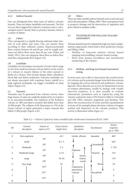
volcanic explosivity index (VEI) listed in Table 4.2 (Newhall<br />
and Self,1982),intensity,magnitude and duration.This<br />
allows the reconstruction of events and their quantification<br />
in terms of, <strong>for</strong> example, plume elevation, volume of magma<br />
emitted and dispersion of the volcanic products. This<br />
activity is illustrated within Figure 4.1.<br />
Table 4.2 — Volcanic Explosivity Index (modified after Smithsonian Institution/SEAN, 1989)<br />
VEI<br />
General Volume of Cloud column Qualitative<br />
description tephra (m 3 ) height (km) description<br />
Classification<br />
Historic<br />
eruptions<br />
up to 1985<br />
0 Non-explosive


