Surface Water - Alabama Department of Environmental Management
Surface Water - Alabama Department of Environmental Management
Surface Water - Alabama Department of Environmental Management

Create successful ePaper yourself
Turn your PDF publications into a flip-book with our unique Google optimized e-Paper software.
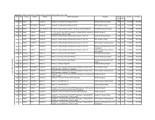
Appendix E. Stations assessed in the Black Warrior and Cahaba River Basins since 1992.<br />
CU Sub County Station Stream Station Description Program Most Ecoregion<br />
Lat Dec Lon Dec<br />
recent<br />
data<br />
0202 030 Shelby C2 Cahaba R. Cahaba R. at Caldwell Ford Bridge at CR 29 Ambient Montoring Program 2002 67h 33.41528 -86.74000<br />
0202 030 Shelby EPACRAH-1 Cahaba R. Cahaba R. at Caldwell Ford Bridge at CR 29 EPA Cahaba R. Study 2002 67h 33.41528 -86.74000<br />
0202 030 Shelby CA2U5-27 Little Cahaba R, UT Tributary to Little Cahaba R. approx. 1/8 mile us <strong>of</strong> Little Cahaba R. ALAMAP Monitoring Program 2001 67h 33.43968 -86.69557<br />
to<br />
0202 030 Shelby CARS-5 Cahaba R. ~1.75 mi ds <strong>of</strong> R.view WWTP discharge nr Caldwell Mill Rd crossing, ds WQDS-Cahaba R. 1995 67h 33.41551 -86.73952<br />
<strong>of</strong> lowhead dam (~CR-2 <strong>of</strong> 1995)<br />
0202 030 Shelby CAHS-1 Cahaba R. Cahaba R. at Bains Bridge (Old Montomery Hwy) Co. Hwy 175 303(d) Monitoring Program 2003 67h 33.36331 -86.81360<br />
0202 030 Shelby EPACR-6 Cahaba R. Cahaba R. at Bains Bridge (Old Montomery Hwy) Co. Hwy 175 EPA Cahaba R. Study 2002 67h 33.36331 -86.81360<br />
0202 030 Shelby GSACR-6 Cahaba R. Cahaba R. at Bains Bridge (Old Montomery Hwy) Co. Hwy 175 GSA Cahaba R. Bioassessment 2002 67h 33.36331 -86.81360<br />
0202 030 Shelby SU-6 Cahaba R. Cahaba R. at Bains Bridge (Old Montomery Hwy) Co. Hwy 175 Samford U's Bioassessment <strong>of</strong> the 2001 67h 33.36331 -86.81360<br />
U Cahaba R<br />
0202 030 Shelby UAB-14 Cahaba R. Cahaba R. at Bains Bridge (Old Montomery Hwy) Co. Hwy 175 UAB's Biological Communities <strong>of</strong> 1998 67h 33.36331 -86.81360<br />
the Cahaba R<br />
0202 030 Jefferson PA-1A Patton Cr. Patton Cr. at AL Hwy 150 (Trend Station) 303(d) Monitoring Program 2003 67h 33.36679 -86.82198<br />
0202 030 Jefferson PA-1A Patton Cr. Patton Cr. at AL Hwy 150 (Trend Station) Ambient Monitoring Program 2002 67h 33.36679 -86.82198<br />
Appendix E--Page 3 <strong>of</strong> 40<br />
0202 030 Jefferson PA1A Patton Cr. Patton Cr. at AL Hwy 150 (Trend Station) Periphyton Bioassessment Pilot 2002 67h 33.36679 -86.82198<br />
Project<br />
0202 030 Jefferson PATJ-4 Patton Cr. Patton Cr. at Patton Chapel Rd 303(d) Monitoring Program 2003 67h 33.38894 -86.82718<br />
0202 030 Jefferson EPACRBH-1 Cahaba R. Cahaba R. <strong>of</strong>f <strong>of</strong> unnamed road <strong>of</strong>f <strong>of</strong> Rocky Ridge Rd. at Acton Ford? EPA Cahaba R. Study 2002 67h 33.39300 -86.76728<br />
(GSA description: Cahaba R. nr. Altadena)<br />
0202 030 Jefferson GSACR-7 Cahaba R. Cahaba R. <strong>of</strong>f <strong>of</strong> unnamed road <strong>of</strong>f <strong>of</strong> Rocky Ridge Rd. at Acton Ford? GSA Cahaba R. Bioassessment 2002 67h 33.39300 -86.76728<br />
(GSA description: Cahaba R. nr. Altadena)<br />
0202 030 Jefferson CARJ-1 Cahaba R. Cahaba R. ~100 FT US OF R.view WWTP discharge ds <strong>of</strong> lowhead dam WQDS-Cahaba R. 1998 67h 33.42240 -86.71963<br />
(~CR-1 <strong>of</strong> 1995)<br />
0202 030 Jefferson CARJ-2 Cahaba R. Cahaba R. ~50 ft ds <strong>of</strong> R.view WWTP discharge WQDS-Cahaba R. 1998 67h 33.42242 -86.71963<br />
0202 030 Jefferson USGSPAJ-1 Patton Cr. Patton Cr. near Bluff Park, AL USGS Landuse Gradient Study 1999 67h 33.38870 -86.82755<br />
0202 030 Jefferson 02423515 Patton Cr. Patton Cr. near Bluff Park, AL USGS Sampling Station 1998 67h 33.38870 -86.82755<br />
0202 030 Shelby CARS-3 Cahaba R. Cahaba R. ~0.75 mi ds <strong>of</strong> R.view WWTP dishcarge and ~100 ft us <strong>of</strong> an WQDS-Cahaba R. 1998 67h 33.41389 -86.72846<br />
unnamed trib and Hoover-Inverness WWTP discharge<br />
0202 030 Shelby CARS-4 Cahaba R. Cahaba R. ~100 ft ds <strong>of</strong> Hoover Inverness WWTP discharge WQDS-Cahaba R. 1998 67h 33.41295 -86.72952<br />
0202 030 Shelby CR-2 Cahaba R. Cahaba R. ~1.75 mi ds <strong>of</strong> R.view WWTP discharge nr Caldwell Mill Rd<br />
crossing, ds <strong>of</strong> lowhead dam (~CR-2 <strong>of</strong> 1995)<br />
0202 030 Shelby GSACR-8 Cahaba R. Cahaba R. ~1.75 mi ds <strong>of</strong> R.view WWTP discharge nr Caldwell Mill Rd<br />
crossing, ds <strong>of</strong> lowhead dam (~CR-2 <strong>of</strong> 1995)<br />
0202 030 Shelby SU-3 Cahaba R. Cahaba R. ~1.75 mi ds <strong>of</strong> R.view WWTP discharge nr Caldwell Mill Rd<br />
crossing, ds <strong>of</strong> lowhead dam (~CR-2 <strong>of</strong> 1995)<br />
Cahaba R. Intensive Study 1995 67h 33.41551 -86.73952<br />
GSA Cahaba R. Bioassessment 2002 67h 33.41551 -86.73952<br />
Samford U's Bioassessment <strong>of</strong> the<br />
U Cahaba R<br />
2001 67h 33.41551 -86.73952