Surface Water - Alabama Department of Environmental Management
Surface Water - Alabama Department of Environmental Management
Surface Water - Alabama Department of Environmental Management

Create successful ePaper yourself
Turn your PDF publications into a flip-book with our unique Google optimized e-Paper software.
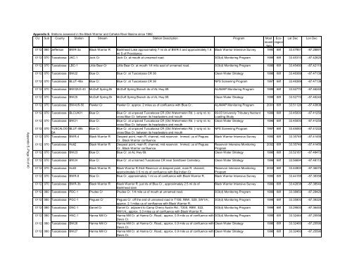
Appendix E. Stations assessed in the Black Warrior and Cahaba River Basins since 1992.<br />
CU Sub County Station Stream Station Description Program Most Ecoregion<br />
Lat Dec Lon Dec<br />
recent<br />
data<br />
0112 060 Jefferson BWR-3a Black Warrior R Bankhead Lake approximately 7 mi ds <strong>of</strong> BWR-3 and approximately 1.8 Black Warrior Intensive Survey 1990 68f 33.47951 -87.28891<br />
mi S <strong>of</strong> Providence<br />
0112 070 Tuscaloosa JKC-1 Jock Cr Jock Cr. at mouth at unnamed road. 303(d) Monitoring Program 1999 68f 33.45310 -87.42820<br />
0112 070 Tuscaloosa LBC-1 Little Bear Cr Little Bear Cr. at mouth 1/4 mile east <strong>of</strong> unnamed road. 303(d) Monitoring Program 1999 68f 33.45490 -87.42110<br />
0112 070 Tuscaloosa BW22 Blue Cr. Blue Cr. at Tuscaloosa CR 38 Clean <strong>Water</strong> Strategy 1996 68f 33.48389 -87.47139<br />
0112 070 Tuscaloosa BLUT-49a Blue Cr. Blue Cr. at Tuscaloosa CR 38 NPS Screening Program 1997 68f 33.48389 -87.47139<br />
0112 070 Tuscaloosa BW02U3-43 McDuff Spring Br McDuff Spring Branch ds <strong>of</strong> AL Hwy 69. ALAMAP Monitoring Program 1999 68f 33.52770 -87.46240<br />
0112 070 Tuscaloosa BW25 McDuff Spring Br McDuff Spring Branch ds <strong>of</strong> AL Hwy 69. Clean <strong>Water</strong> Strategy 1996 68f 33.52770 -87.46240<br />
0112 070 Tuscaloosa BW4U5-50 Pewter Cr Pewter Cr. approx. 2 miles us <strong>of</strong> confluence with Blue Cr.. ALAMAP Monitoring Program 2001 68f 33.51126 -87.43808<br />
Appendix E--Page 34 <strong>of</strong> 40<br />
0112 070 Tuscaloosa BLCUA01 Blue Cr. Blue Cr. at unpaved Tuscaloosa CR (Old <strong>Water</strong>melon Rd. )--only rd. to 99-00 University Tributary Nutrient 1999 68f 33.45000 -87.41250<br />
cross Blue Cr. between its headwaters and mouth<br />
Loading Study<br />
0112 070 Tuscaloosa BW21 Blue Cr. Blue Cr. at unpaved Tuscaloosa CR (Old <strong>Water</strong>melon Rd. )--only rd. to Clean <strong>Water</strong> Strategy 1996 68f 33.45000 -87.41250<br />
cross Blue Cr. between its headwaters and mouth<br />
0112 070 TUSCALOO BLUT-49b Blue Cr. Blue Cr. at unpaved Tuscaloosa CR (Old <strong>Water</strong>melon Rd. )--only rd. to NPS Screening Program 1997 68f 33.45083 -87.41222<br />
SA<br />
cross Blue Cr. between its headwaters and mouth<br />
0112 070 Tuscaloosa BWR-4 Black Warrior R Deepest point, main R. channel, mid-reservoir. Immed. us <strong>of</strong> Pegues Black Warrior Intensive Survey 1990 68f 33.35749 -87.41455<br />
Cr., Black Warrior confluence.<br />
0112 070 Tuscaloosa Holt2 Black Warrior R Deepest point, main R. channel, mid-reservoir. Immed. us <strong>of</strong> Pegues Reservoir Intensive Monitoring 2002 68f 33.35749 -87.41455<br />
Cr., Black Warrior confluence.<br />
Program<br />
0112 070 Tuscaloosa BW23 Blue Cr. Blue Cr. at AL Hwy 69. Clean <strong>Water</strong> Strategy 1996 68f 33.52167 -87.48472<br />
0112 070 Tuscaloosa BW24 Blue Cr. Blue Cr. at unnamed Tuscaloosa CR near Sandtown Cemetary. Clean <strong>Water</strong> Strategy 1996 68f 33.56694 -87.48110<br />
0112 070 Tuscaloosa Holt3 Black Warrior R. Black Warrior R./Holt Reservoir at deepest point, main R. channel, Reservoir Intensive Monitoring 2002 68f 33.44900 -87.36570<br />
approximately 0.5 mi ds <strong>of</strong> confluence with Big Indian Cr.<br />
Program<br />
0112 070 Tuscaloosa BWR-9 Blue Cr. Blue Cr. approximately 1 mi us <strong>of</strong> confluence with Black Warrior R. Black Warrior Intensive Survey 1990 68f 33.44159 -87.38358<br />
0112 070 Tuscaloosa BWR-3b Black Warrior R Black Warrior R. just ds <strong>of</strong> Blue Cr., approximately 2.5 mi ds <strong>of</strong> Black Warrior Intensive Survey 1990 68f 33.42838 -87.38540<br />
Bankhead dam<br />
0112 080 Tuscaloosa PDC-1 Prudes Cr Prudes Cr. 1/4 mile us <strong>of</strong> mouth at unnamed road. 303(d) Monitoring Program 1999 68f 33.38950 -87.29420<br />
0112 080 Tuscaloosa PGC-1 Pegues Cr Pegues Cr. <strong>of</strong>f the end <strong>of</strong> unnamed road in T19S, R8W, S29, SW1/4.; 303(d) Monitoring Program 1999 68f 33.35900 -87.39320<br />
approx. 2.1 miles us <strong>of</strong> confluence with Black Warrior R..<br />
0112 080 Tuscaloosa DNC-1 Daniel Cr Daniel Cr. adjacent to Camp Cherry Austin Rd.; T20S, R8W, S22, 303(d) Monitoring Program 1999 68f 33.29500 -87.36440<br />
NW1/4.; approx. 3.0 miles us <strong>of</strong> confluence with Black Warrior R..<br />
0112 080 Tuscaloosa HNC-1 Hanna Mill Cr Hanna Mill Cr. at Hanna Cr. Road.; approx. 0.9 mile us <strong>of</strong> confluence with 303(d) Monitoring Program 1999 68f 33.32444 -87.25556<br />
Davis Cr.<br />
0112 080 Tuscaloosa BW26 Hanna Mill Cr Hanna Mill Cr. at Hanna Cr. Road.; approx. 0.9 mile us <strong>of</strong> confluence with Clean <strong>Water</strong> Strategy 1996 68f 33.32460 -87.25590<br />
Davis Cr.<br />
0112 080 Tuscaloosa BW27 Hanna Mill Cr Hanna Mill Cr. at Hanna Cr. Road.; approx. 0.9 mile us <strong>of</strong> confluence with Clean <strong>Water</strong> Strategy 1996 68f 33.32460 -87.25590<br />
Davis Cr.