Surface Water - Alabama Department of Environmental Management
Surface Water - Alabama Department of Environmental Management
Surface Water - Alabama Department of Environmental Management

Create successful ePaper yourself
Turn your PDF publications into a flip-book with our unique Google optimized e-Paper software.
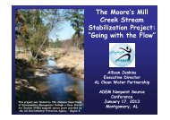
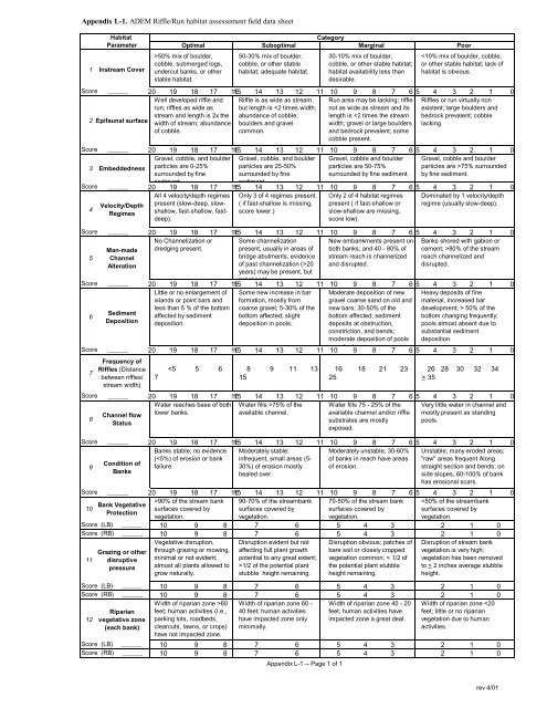
Appendix L-1. ADEM Riffle/Run habitat assessement field data sheet<br />
Habitat<br />
Category<br />
Parameter Optimal Suboptimal Marginal Poor<br />
1 Instream Cover<br />
>50% mix <strong>of</strong> boulder,<br />
cobble, submerged logs,<br />
undercut banks, or other<br />
stable habitat.<br />
50-30% mix <strong>of</strong> boulder,<br />
cobble, or other stable<br />
habitat; adequate habitat.<br />
30-10% mix <strong>of</strong> boulder,<br />
cobble, or other stable habitat;<br />
habitat availability less than<br />
desirable.<br />
80% <strong>of</strong> the stream<br />
reach channelized and<br />
disrupted.<br />
Score ______ 20 19 18 17 1615 14 13 12 11 10 9 8 7 6 5 4 3 2 1 0<br />
Little or no enlargement <strong>of</strong><br />
islands or point bars and<br />
Some new increase in bar<br />
formation, mostly from<br />
6<br />
less than 5 % <strong>of</strong> the bottom coarse gravel; 5-30% <strong>of</strong> the<br />
Sediment<br />
affected by sediment bottom affected; slight<br />
Deposition deposition.<br />
deposition in pools.<br />
Moderate deposition <strong>of</strong> new<br />
gravel coarse sand on old and<br />
new bars; 30-50% <strong>of</strong> the<br />
bottom affected; sediment<br />
deposits at obstruction,<br />
constriction, and bends;<br />
moderate deposition <strong>of</strong> pools<br />
prevalent.<br />
Heavy deposits <strong>of</strong> fine<br />
material, increased bar<br />
development; > 50% <strong>of</strong> the<br />
bottom changing frequently;<br />
pools almost absent due to<br />
substantial sediment<br />
deposition.<br />
Score ______ 20 19 18 17 1615 14 13 12 11 10 9 8 7 6 5 4 3 2 1 0<br />
7<br />
8<br />
Frequency <strong>of</strong><br />
Riffles (Distance<br />
between riffles/<br />
stream width)<br />
Channel flow<br />
Status<br />
7<br />
35<br />
Score ______ 20 19 18 17 1615 14 13 12 11 10 9 8 7 6 5 4 3 2 1 0<br />
<strong>Water</strong> reaches base <strong>of</strong> both <strong>Water</strong> fills >75% <strong>of</strong> the<br />
lower banks.<br />
available channel.<br />
Condition <strong>of</strong><br />
Banks<br />
<strong>Water</strong> fills 75 - 25% <strong>of</strong> the<br />
available channel and/or riffle<br />
substrates are mostly<br />
exposed.<br />
Very little water in channel and<br />
mostly present as standing<br />
pools.<br />
Score ______ 20 19 18 17 1615 14 13 12 11 10 9 8 7 6 5 4 3 2 1 0<br />
Banks stable; no evidence<br />
Moderately unstable; 30-60%<br />
(90% <strong>of</strong> the stream bank 90-70% <strong>of</strong> the streambank 70-50% <strong>of</strong> the stream bank 1/2 <strong>of</strong> the potential plant<br />
stubble height remaining.<br />
Disruption obvious; patches <strong>of</strong><br />
bare soil or closely cropped<br />
vegetation common; < 1/2 <strong>of</strong><br />
the potential plant stubble<br />
height remaining.<br />
Disruption <strong>of</strong> stream bank<br />
vegetation is very high;<br />
vegetation has been removed<br />
to < 2 inches average stubble<br />
height.<br />
Score (LB) ______ 10 9 8 7 6 5 4 3 2 1 0<br />
Score (RB) ______ 10 9 8 7 6 5 4 3 2 1 0<br />
12<br />
Riparian<br />
vegetative zone<br />
(each bank)<br />
Width <strong>of</strong> riparian zone >60<br />
feet; human activities (i.e.,<br />
parking lots, roadbeds,<br />
clearcuts, lawns, or crops)<br />
have not impacted zone.<br />
Width <strong>of</strong> riparian zone 60 -<br />
40 feet; human activities<br />
have impacted zone only<br />
minimally.<br />
Width <strong>of</strong> riparian zone 40 - 20<br />
feet; human activities have<br />
impacted zone a great deal.<br />
Width <strong>of</strong> riparian zone