Outline of Quino Recovery Plan - The Xerces Society
Outline of Quino Recovery Plan - The Xerces Society
Outline of Quino Recovery Plan - The Xerces Society

You also want an ePaper? Increase the reach of your titles
YUMPU automatically turns print PDFs into web optimized ePapers that Google loves.
I. INTRODUCTION<br />
A. Brief Overview<br />
<strong>The</strong> distribution and abundance <strong>of</strong> the <strong>Quino</strong> checkerspot butterfly (Euphydryas<br />
editha quino) have been dramatically reduced during the past century as a result<br />
<strong>of</strong> agricultural and urban development and other land-use changes in southern<br />
California. Immediate protection and management <strong>of</strong> the habitats that support<br />
the species, initiation <strong>of</strong> a captive propagation program, and development <strong>of</strong> the<br />
monitoring scheme and research agenda described in this recovery plan will be<br />
necessary to prevent extinction <strong>of</strong> the <strong>Quino</strong> checkerspot.<br />
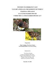
<strong>The</strong> <strong>Quino</strong> checkerspot (Figure 1) is now known only from western Riverside<br />
County, southern San Diego County, and northern Baja California, Mexico,<br />
although the historic range <strong>of</strong> this taxon included much <strong>of</strong> coastal California<br />
south <strong>of</strong> Ventura County and inland valleys south <strong>of</strong> the Tehachapi Mountains<br />
(U.S. Fish and Wildlife Service database). More than 75 percent <strong>of</strong> the <strong>Quino</strong><br />
checkerspot’s historic range has been lost (Brown 1991, U.S. Fish and Wildlife<br />
Service database), including more than 90 percent <strong>of</strong> the coastal mesa and bluff<br />
distribution. <strong>Quino</strong> checkerspot populations have been reduced in number and<br />
size by more than 95 percent range-wide primarily due to direct and indirect<br />
human impacts including habitat loss and fragmentation, invasion <strong>of</strong> nonnative<br />
plant species, and disrupted fire regimes (D. Bauer, D. Murphy, and M. Singer,<br />
pers. comm.).<br />
This recovery plan describes six geographic areas (<strong>Recovery</strong> Units) containing<br />
habitat that supports extant <strong>Quino</strong> checkerspot populations (Figure 2, Figure 3).<br />
<strong>Recovery</strong> Units contain both lands that are considered essential and lands that<br />
are not considered essential to the conservation <strong>of</strong> the species. Determination <strong>of</strong><br />
management needs and distribution <strong>of</strong> habitat required for long-term persistence<br />
<strong>of</strong> the species will require further surveys, monitoring, modeling, and other<br />
research described in the recovery task portion <strong>of</strong> this document. Habitat within<br />
the current known distribution <strong>of</strong> the species ranges from moderately to highly<br />
1